 地图
地图  地图集
地图集  珍本
珍本  版画
版画  天文仪器
天文仪器 注册以了解我们最新的收购、展览和活动


地址
纽约
PO Box 329, Larchmont, NY, USA
开放时间,伦敦画廊
周一至周五:10:00-18:00
周六请预约
公休日:所有银行假日以及 8月1日至31日
营业时间,纽约
仅限预约

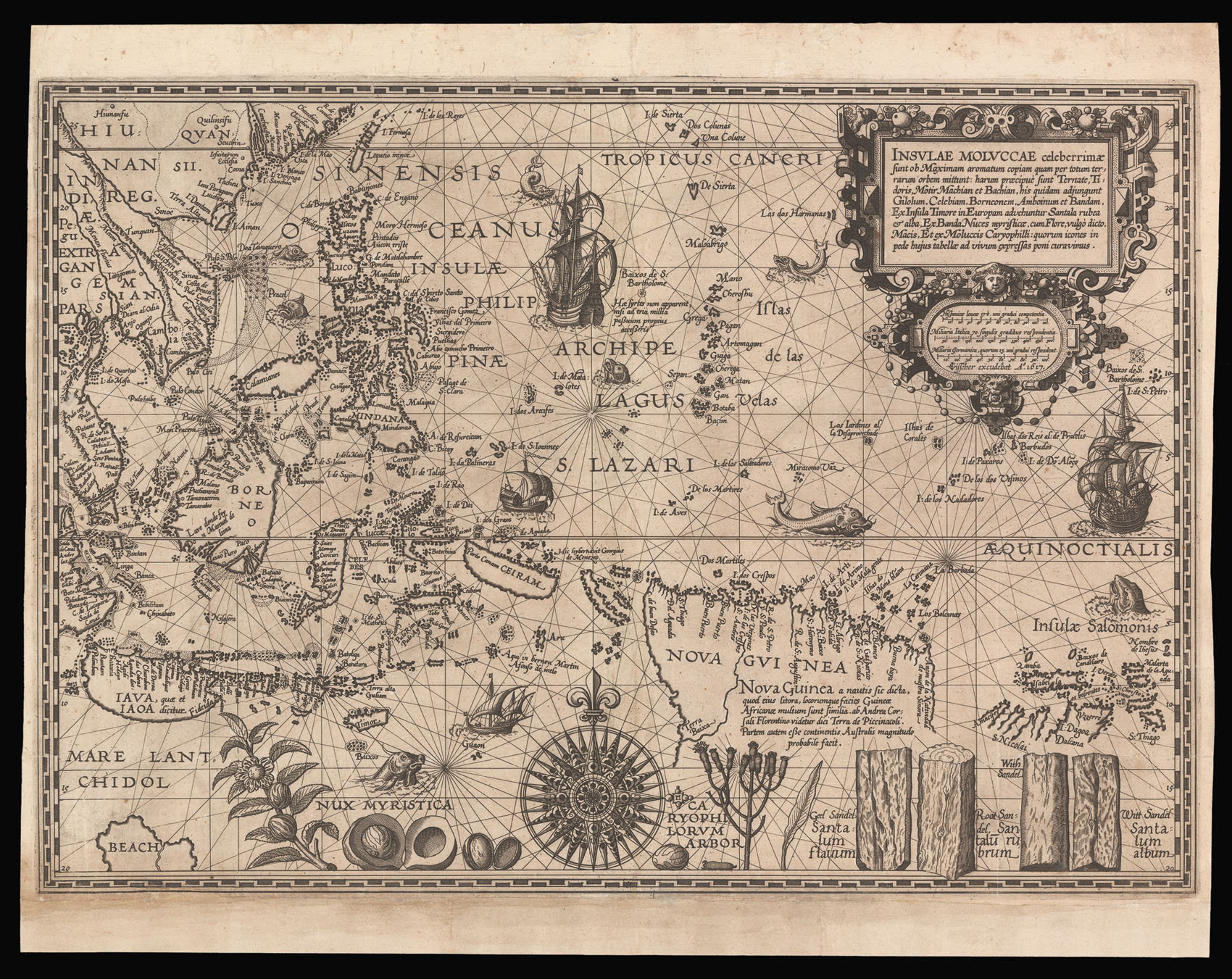
Insulae Moluccae celeberrimæ sunt ob Maximam aromatum copiam quam per totum terrarum orbem mittunt…
- 作者: PLANCIUS, Petrus
- 出版地: Amsterdam
- 出版商: Visscher
- 发布日期: 1617.
- 物理描述: Engraved chart, backed on Japan paper, lower margin renewed in part with minor loss to a short section of the neatline.
- 方面: 380 by 540mm. (15 by 21.25 inches).
- 库存参考: 12636
笔记
A rare Visscher imprint of Petrus Plancius’s seminal chart of the East Indies. The chart was instrumental in helping the Dutch break the Portuguese monopoly on the spice trade in the East Indies.
Following the successful Dutch rebellion against their Spanish overlords in 1579, the Dutch struck out to take a share in the lucrative trade in spices from the Far East. In 1592 Petrus Plancius, a cartographer and Flemish minister in the Calvinist Reform Church, sponsored a covert mission to obtain confidential Portuguese manuscript charts from Lisbon. The Houtman brothers, Cornelius and Frederick, acquired 25 manuscript charts by the Portuguese cartographer, Bartolomeu Lasso, from which Plancius compiled this map; engraved by Johannes Doetecum. It was first published as a loose sheet in 1595, but it was also bound into some copies of Linschoten’s ‘Itinerario’.
Cartographically the map is a huge improvement on previous printed maps of Southeast Asia with the Sunda Islands, the Moluccas, and much of the mainland coast well-delineated. The large islands of the Philippines, such as Luzon and Mindanao, are well-drawn, and although the cluster of islands between them are crude, they are at least well placed and correctly named. Palawan is confused with the “Calamianes” a group of small islands to its east. To the southeast, a vast New Guinea has been tentatively assigned to a theoretical southern continent; Plancius confuses its west coast, present-day Irian Jaya, with the island of Seram (Ceriam), upon which he places the the Guinean port of “Canam”. This confusion was to be compounded by Linschoten a year later and was depicted by Rossi on his map of 1680. On the mainland the fictitious transpeninsula waterway is shown, as is a phantom lake, dotted with islands, west of Siam. Plancius curiously omits Singapore. At the bottom of the map he depicts the various commodities that the islands have to offer – the key to any prospective Dutch investor. These include cloves (Caryophilorum Arbor), nutmeg (nux Myristica) and red and white sandalwood (Santulum): sought after for their culinary and medicinal properties.
相关项目


请注册以了解最新珍品、展览和活动信息
地址
纽约
PO Box 329, Larchmont, NY, USA
开放时间,伦敦画廊
周一至周五:10:00-18:00
周六请预约
公休日:所有银行假日以及 8月1日至31日
营业时间,纽约
仅限预约