 地图
地图  地图集
地图集  珍本
珍本  版画
版画  天文仪器
天文仪器 注册以了解我们最新的收购、展览和活动


地址
纽约
PO Box 329, Larchmont, NY, USA
开放时间,伦敦画廊
周一至周五:10:00-18:00
周六请预约
公休日:所有银行假日以及 8月1日至31日
营业时间,纽约
仅限预约

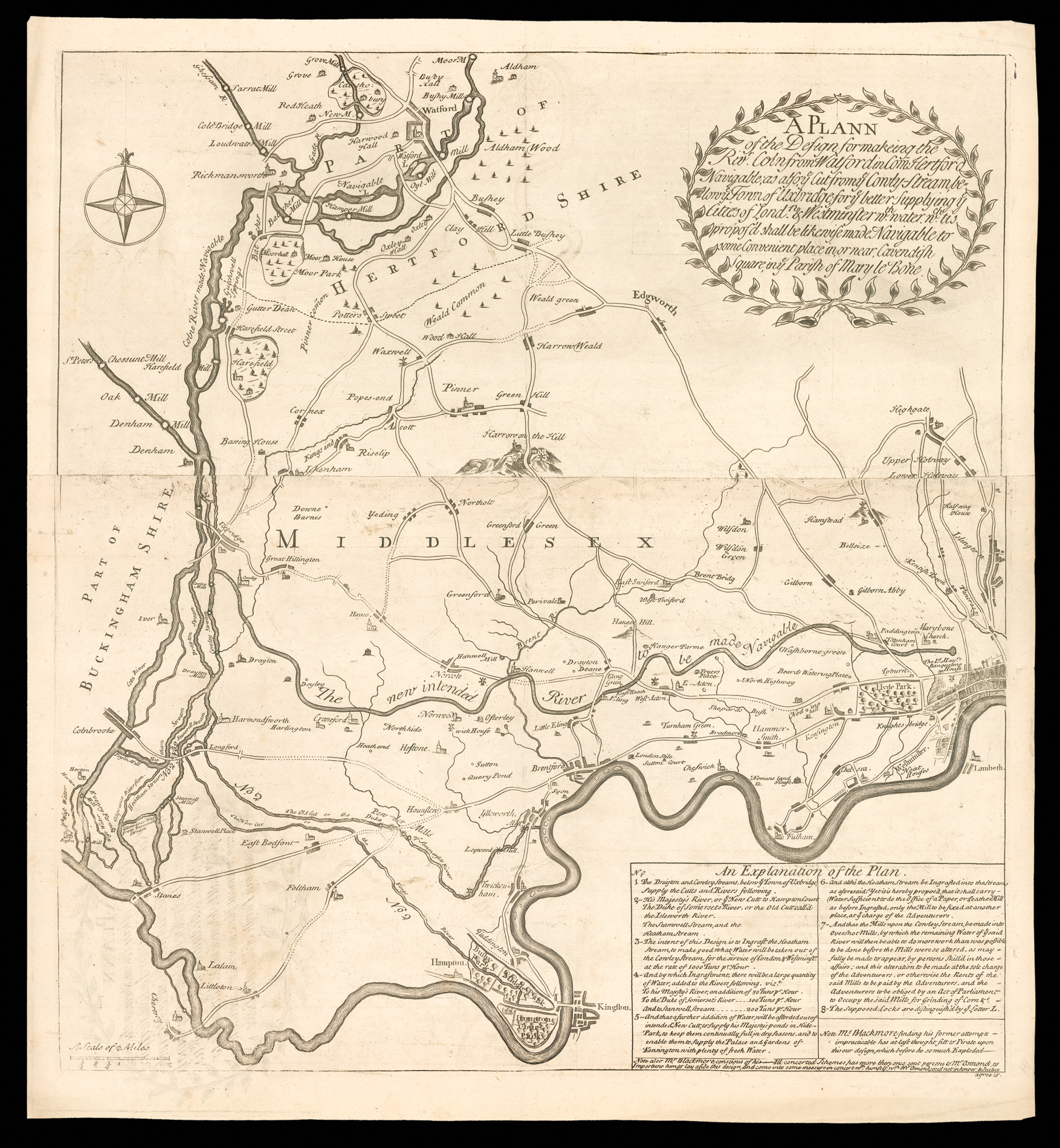
A Plann of the Design for makeing the Rivr. Coln from Watford in Com Hertford Navigable Cut from ye Cowly-Stream, below ye Town of Uxbridge; for ye better Supplying ye Cities of Londn. & Westminster w.th water w[hi]ch tis propos’s shall be likewise made Navigable to some Convenient place in, or near, Cavendish Square, in ye Parish of Mary le Bone.
- 作者: ACHERLEY, Thomas
- 出版地: London
- 出版商: Thomas Acherley
- 发布日期: c1723.
- 物理描述: Engraved map.
- 方面: 529 by 485mm. (20.75 by 19 inches).
- 库存参考: 11342
笔记
This is the largest of the various maps associated with the various proposals for the River Colne Navigation. The map was first published as a single-sheet (with a different title) and then subsequently revised and updated reflecting the ebb and flow of the successive proposals, objections and counter-proposals placed before Parliament and the public between 1719 and 1723. This is the third identified state of the map, now on two sheets, with the new title as above.
In the text, ‘An Explanation of the Plan. …’, Acherley gives a relatively detailed discussion of his own proposals, clearly directed towards a knowledgeable reader, presumably therefore to be distributed as part of his application to Parliament. However, he was also unable to resist a criticism of the rival scheme (and its proposer):
“Note Mr. Blackmore finding his former attempts impracticable has at last thought fitt to Pirate upon this our design, which before he so much Exploded__ [rule] Note also Mr Blackmore conspicuous of his [erasure] Ill concerned Schemes, has more then once sent persons to Mr. Osmond, to Importune him to lay aside this design, and come into some measurs in concert w.th himself, w[hi]ch Mr. Osmond, could not in honour & justice agree to.”
In this state, the existing ‘The new intended River’ from ‘The Old Cut’ west of Hounslow to the reservoir below ‘Marybone Church’ has been completely erased and ‘The new intended River’ inserted, extending from ‘Cowley Stream’ to a reservoir below ‘Marybone Church’.
Within London there are many new names, ‘The L[or]d. May[o]rs. Banqueting House’, ‘Tottenham Court’, ‘Knight-bridge’, ‘Wasborne green’, ‘Noding hill’, ‘Sheparrds Bush’, moving to the west; the place names north-east of London are new, including ‘Pancras’, ‘Kentish Town’, ‘Bellsize’, ‘Islington’, ‘Hanstead’, Wilsdon’ and ‘Wilsdon Green’.
参考书目
- Hanson, Contemporary Printed Sources for British and Irish Economic History, 3548
- Kress, Kress Library of Business and Economics. Catalogue Supplement, 1628
- BL, Maps 181.a.2. II.(138)
- BL, Maps 181.a.2. II.(169)
- BL, Maps Crace Port. 18.59.(1.): all mounted on a BM/BL backing obscuring the printed title on the verso.
相关项目


请注册以了解最新珍品、展览和活动信息
地址
纽约
PO Box 329, Larchmont, NY, USA
开放时间,伦敦画廊
周一至周五:10:00-18:00
周六请预约
公休日:所有银行假日以及 8月1日至31日
营业时间,纽约
仅限预约