 地图
地图  地图集
地图集  珍本
珍本  版画
版画  天文仪器
天文仪器 注册以了解我们最新的收购、展览和活动


地址
纽约
PO Box 329, Larchmont, NY, USA
开放时间,伦敦画廊
周一至周五:10:00-18:00
周六请预约
公休日:所有银行假日以及 8月1日至31日
营业时间,纽约
仅限预约

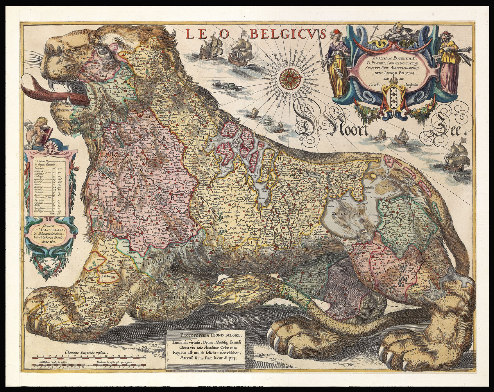
Leo Belgicus.
- 作者: GERRITSZ, Hessel
- 出版地: Amsterdam
- 出版商: Jodocus Hondius
- 发布日期: 1611.
- 物理描述: Hand-coloured, engraved map, trimmed to neatline, remargined.
- 方面: 430 by 560mm (17 by 22 inches).
- 库存参考: 2858
笔记
In 1608, the cartographer Hessel Gerritsz (1581-1632) published a new version of the Leo Belgicus with the Netherlands orientated with the west at the top. Again the lion’s back follows the coastline, however, this time he is shown walking on all fours (passant), with his head facing south – towards the Spanish threat.
The genesis of this map is somewhat complicated, as no example of Gerritsz’ original survives. The waters are further muddied by the fact that Gerritsz would appear to have engraved two, almost identical, copper plates. Although neither of the first states survive, it is likely that the works were engraved between 1608 and 1612, for two reasons: first, Gerritsz set up on his own in 1608, having been previously employed by Willem Blaeu, second, if one looks at the cartography, the map is unlikely to have been engraved after 1612, as the lakes of northern Holland have yet to be reclaimed.
To the left is a table of towns and villages, to the upper right is an elaborate title cartouche. Below the lion’s feet is a legend that reads:
“The Leo Belgicus as a personification of the Netherlands. My fame of Trojan courage and strength, my glory as another Mars are known world wide. But far more happy would I be than many a king, if the gods would grant me everlasting peace”.
Gerritsz sold the plates for the map to Cornelius Janszoon, who in turn sold them to Jodocus Hondius, who issued this edition in 1611.
参考书目
- H.A.M. van der Heijden, Leo Belgicus: An illustrated and annotated cartobibliography, 2nd ed., (Alphen aan den Rijn: Canaletto, 2006), 15.4.
相关项目


请注册以了解最新珍品、展览和活动信息
地址
纽约
PO Box 329, Larchmont, NY, USA
开放时间,伦敦画廊
周一至周五:10:00-18:00
周六请预约
公休日:所有银行假日以及 8月1日至31日
营业时间,纽约
仅限预约