 地图
地图  地图集
地图集  珍本
珍本  版画
版画  天文仪器
天文仪器 注册以了解我们最新的收购、展览和活动


地址
纽约
PO Box 329, Larchmont, NY, USA
开放时间,伦敦画廊
周一至周五:10:00-18:00
周六请预约
公休日:所有银行假日以及 8月1日至31日
营业时间,纽约
仅限预约

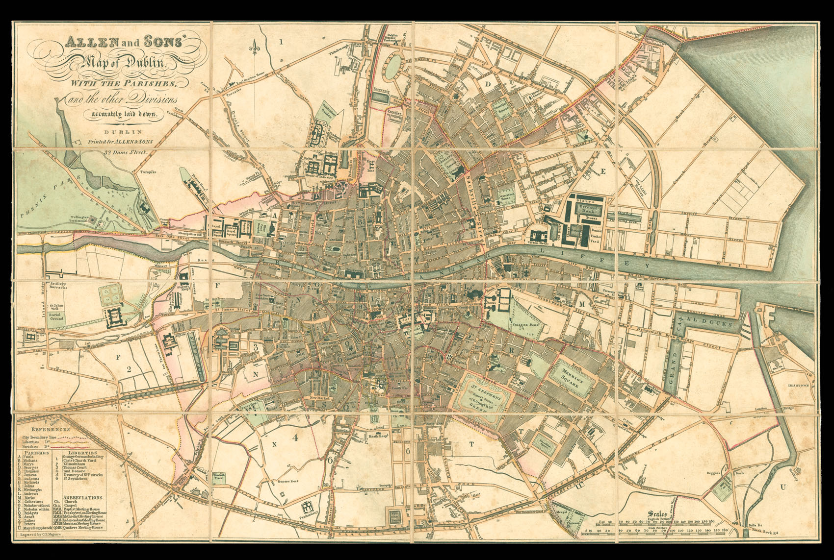
Allen and Sons' Map of Dublin. With the Parishes, and the other Divisions accurately laid down.
- 作者: ALLEN, William
- 出版地: Dublin
- 出版商: Printed by Allen & Sons, 32 Dame Street
- 发布日期: c.1824
- 物理描述: Engraved plan, original hand colour, dissected and mounted on linen, folding into original publisher's slipcase, with label pasted on.
- 方面: 325 by 520mm. (12.75 by 20.5 inches).
- 库存参考: 10821
笔记
Rare late Georgian plan of Dublin.
The plan marks all major public buildings, including Trinity College, the Royal Hospital, the Custom’s House, Prisons, and the Castle; also shown are squares, roads, canals, and reservoirs. The City boundary line is marked pink, the Liberties yellow, and the Parishes red. To the lower left of the plan is a table of the Parishes and Liberties, and list of the abbreviations; these include churches, chapels, and Meeting Houses for Baptists, Presbyterians, Methodists, Independents, Moravians, and Quakers.
William Allen (d.1825) was a leading Dublin map and printseller, who succeeded the printseller, Richard Bushell, at 88 Dame St, he would late move to 32 Dame St. In 1819 when his two sons Mark and James joined the firm the company traded as Allen and Sons, until Willam’s death in 1825. The sons would continue trading as M.H. & J.W. Allen until 1831. The slipcase bears a date in manuscript of 1824, and the imprint of M.H. & J.W. Allen.
The scale used upon the map is the rather unusual English and Irish Perch. The English Perch, even by the the 1820s, had not been standardised – the English preferring the Rod as a unit of measurement – and could vary between 16 1/2 ft and 25 ft. However, the Irish Perch had been set at 21 ft. This gives the plan a rather large scale of (approx.) 6 inches to the statute mile.
相关项目


请注册以了解最新珍品、展览和活动信息
地址
纽约
PO Box 329, Larchmont, NY, USA
开放时间,伦敦画廊
周一至周五:10:00-18:00
周六请预约
公休日:所有银行假日以及 8月1日至31日
营业时间,纽约
仅限预约