 地图
地图  地图集
地图集  珍本
珍本  版画
版画  天文仪器
天文仪器 注册以了解我们最新的收购、展览和活动


地址
纽约
PO Box 329, Larchmont, NY, USA
开放时间,伦敦画廊
周一至周五:10:00-18:00
周六请预约
公休日:所有银行假日以及 8月1日至31日
营业时间,纽约
仅限预约

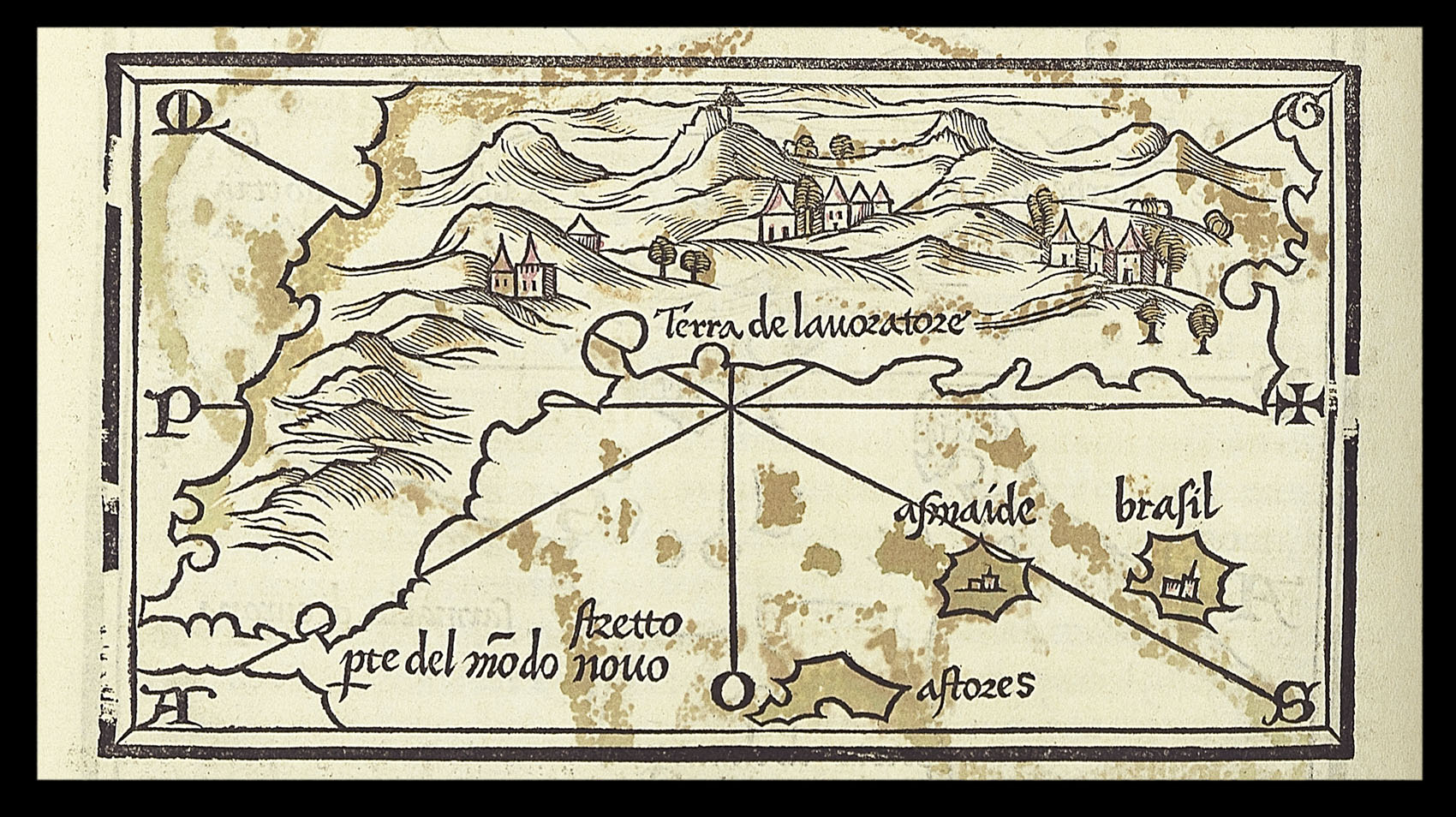
Terra de Lavoratore
- 作者: BORDONE, Benedetto di
- 出版地: Venice
- 出版商: [Nicolo Zoppino]
- 发布日期: 1534
- 物理描述: Woodcut map, with contemporary hand-colour in outline
- 方面: 85 by 145mm. (3.25 by 5.75 inches).
- 库存参考: 3220
笔记
One of the earliest maps to show all of North America, although the geography is derived from that of north-east Asia, as depicted in Bordone’s map of the world: “the two often being interrelated at this time” (Burden).
“Stretto pte del modo novo” depicts the area corresponding to the Caribbean, the land mass shown below it, South America. The fictitious islands of “brasil” and “asmaide” appear lower left.
From the second Zoppino edition of Benedetto di Bordone’s ‘Isolario’, published in 1534. Bordone’s (1460-1539) “Isolario…”, or book of islands, was the first printed isolario to encompass the entire world, the only printed isolario to precede it was the little book of Bartolomeo dalli Sonetti, 1485, which covered only the Aegean islands. The isolario was a popular genre that had first appeared in manuscript examples by Cristoforo Buondelmonte dating from the early fifteenth-century, Bordone expanded on the usual theme to encompass lands beyond the eastern Mediterranean, the Aegean archipelago and the Levant, to guide travellers to other parts of Europe and the world, stretching as far as the Indian Ocean, the African coastline and the New World.
Bordone’s work combines conventional and maritime cartography: the representation of settlements echo maps, and the coastlines are in the style of nautical charts.
参考书目
- Burden 8
- Shirley, BL, T.BORD-1a
- Shirley, World, 59
- Schwartz & Ehrenberg page 17
相关项目


请注册以了解最新珍品、展览和活动信息
地址
纽约
PO Box 329, Larchmont, NY, USA
开放时间,伦敦画廊
周一至周五:10:00-18:00
周六请预约
公休日:所有银行假日以及 8月1日至31日
营业时间,纽约
仅限预约