 地图
地图  地图集
地图集  珍本
珍本  版画
版画  天文仪器
天文仪器 注册以了解我们最新的收购、展览和活动


地址
纽约
PO Box 329, Larchmont, NY, USA
开放时间,伦敦画廊
周一至周五:10:00-18:00
周六请预约
公休日:所有银行假日以及 8月1日至31日
营业时间,纽约
仅限预约

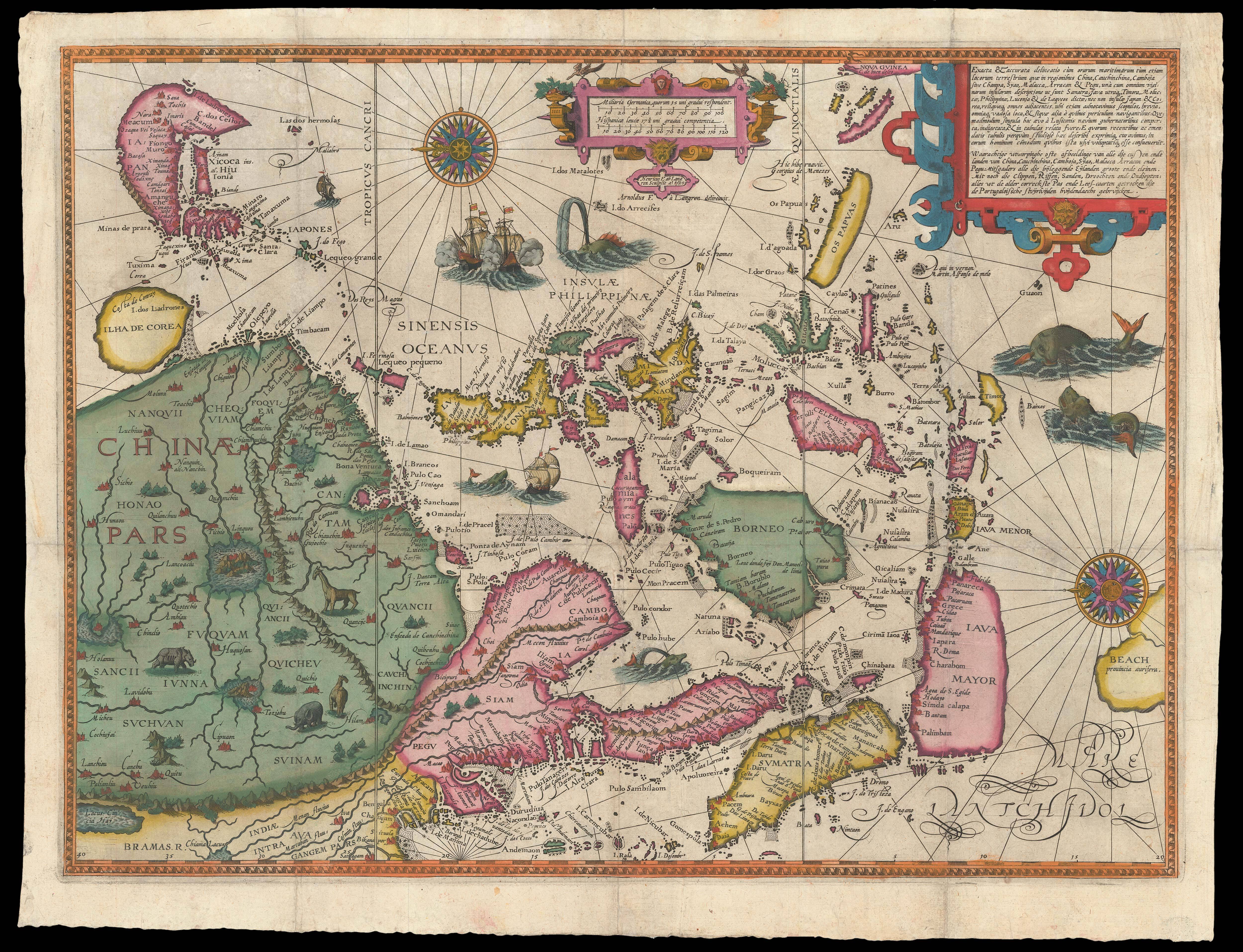
Exacta & accurata delineatio cum orarum maritimdrum tum etjam locorum terrestrium quae in regionibus China Cauchinchina, Camboja sive Champa, Syao, Malacca, Arracan & Pegu, una cum omninum vicinarum insularum descriptione ut sunt Samatra, Java utraq., Timora, Molucca, Philippina, Luconja & de Lequeos dicta; nec non insulae Japan & Corea…
- 作者: LINSCHOTEN, Jan Huyghen van
- 出版地: Amsterdam
- 发布日期: 1595.
- 物理描述: Hand-coloured engraved map.
- 方面: 435 by 568mm. (17.25 by 22.25 inches).
- 库存参考: 15242
笔记
A map of Asia, showing Japan, from Jan Huygen van Linschoten’s groundbreaking travel book.
The coastal and navigational details are taken from the Portuguese portolans copied by Linschoten. It is exceptionally detailed; the first published map of the area to be prepared primarily from Portuguese sources, but also drawing on Petrus Plancius. The outline of southeast Asia and Japan are based on Fernando Vaz Dourado. The islands of the Philippines are drawn after Bartolomeu de Lasso. It also records information from the mythical travel account of Marco Polo, including the “beach provincia auriferain”, which is where Australia would eventually be discovered. The four large interior lakes in China are included after Chinese tradition; Korea is shown as an island.
The maps itself was published in his ‘Itinerario’ of 1595, a book of such importance that every Dutch ship bound for the Indies was issued a copy. It allowed Dutch merchants to circumvent the Portuguese stranglehold on trade to the East. The maps in the first book of the ‘Itinerario’ were engraved by Henricus van Langren, mainly using Portuguese maps owned by Cornelis Claesz, the original publisher of the ‘Itinerario’. They were mostly drawn by de Lasso, and originally acquired by the Houtman brothers between 1592-93, during their secret mission to Portugal at the suggestion of Petrus Plancius, the first official hydrographer of the VOC.
Jan Huyghen van Linschoten (1563–1611) left the Netherlands for Spain in 1576 and secured passage to India in 1583 as secretary to Dominican Vicente da Fonseca, the newly-appointed Portuguese Archbishop of Goa, which gave him access to secret information, including the East Indies portolan charts guarded for over a century. With an impressive disregard for the trust placed in him, Linschoten began to copy these maps meticulously. On his return to the Netherlands, he wrote an account of his travels in 1595 with prints based on his own drawings and maps incorporating the information stolen from the Portuguese.
相关项目


请注册以了解最新珍品、展览和活动信息
地址
纽约
PO Box 329, Larchmont, NY, USA
开放时间,伦敦画廊
周一至周五:10:00-18:00
周六请预约
公休日:所有银行假日以及 8月1日至31日
营业时间,纽约
仅限预约