 地图
地图  地图集
地图集  珍本
珍本  版画
版画  天文仪器
天文仪器 注册以了解我们最新的收购、展览和活动


地址
纽约
PO Box 329, Larchmont, NY, USA
开放时间,伦敦画廊
周一至周五:10:00-18:00
周六请预约
公休日:所有银行假日以及 8月1日至31日
营业时间,纽约
仅限预约

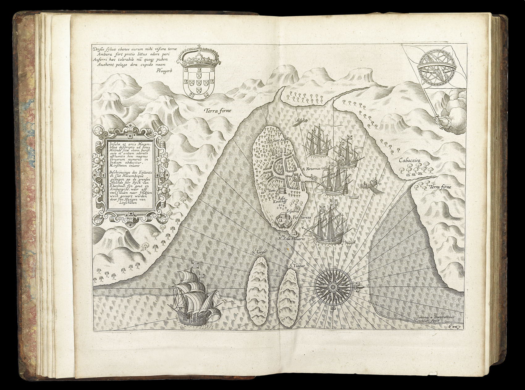
Insulae et arcis Mocambique descriptio ad Fines Melinde…
- 作者: [LINSCHOTEN, Jan Huyghen] and Johan van DOETECUM
- 出版地: [Amsterdam
- 出版商: Chez Evert Cloppenburgh, Marchand libraire, demeurant sur le Water à la Bible Doree
- 发布日期: 1638].
- 物理描述: Engraved map.
- 库存参考: 3469
笔记
A map of the harbour of Malindi (Melinde) on the coast of Mozambique, which was often used as a rest stop by Portuguese and Dutch explorers. A disembodied hand emerges from the clouds at the upper right corner, holding a flag with an armillary sphere on it. The view shows the fortifications of the city, including ships flying the Portuguese standard anchored at the protected harbour.
The island of Mozambique was an important trade centre in Portugese Mombasa in the second half of the sixteenth century on the route from Portugal to India.
From the first book of Jan Huygen van Linschoten’s ‘Itinerario’, the first printed work to include precise sailing instructions for the East Indies. It allowed Dutch merchants to circumvent the Portuguese stranglehold on trade to the East. It was of such economic utility that “it was given to each ship sailing from Holland to India” and soon became “the navigator’s vade mecum for the Eastern seas” (Penrose).
Jan Huyghen van Linschoten (1563–1611) left the Netherlands for Spain in 1576 and secured passage to India in 1583 as secretary to Dominican Vicente da Fonseca, the newly-appointed Portuguese Archbishop of Goa, which gave him access to secret information, including the East Indies portolan charts guarded for over a century. With an impressive disregard for the trust placed in him, Linschoten began to copy these maps meticulously. On his return to the Netherlands, he wrote an account of his travels in 1595 with prints based on his own drawings and maps incorporating the information stolen from the Portuguese.
The first book is especially valuable for its eyewitness account of India, as one of the few Renaissance works on the East to be illustrated from life. Linschoten’s description of Goa is “one of the most original and reliable narratives prepared during the sixteenth century on life at the hub of Portugal’s Eastern empire and still is regarded as one of the best sources for Goa’s history at the peak of its glory”.
参考书目
- Church 252
- Lach, ‘Asia In The Making Of Europe’, Volume 1, pp.198–204 & 482–489
- Sabin 41373
- Shirley 187
- Tiele 686–88.
- JCB (3) II:271
- Klooster, 'Dutch in the Americas', p. 8 & Catalogue Item 5
- Palau 138584
- LOC European Americana 638/67
- David E. Parry, 'The Cartography Of The East Indian Islands', pp. 84–85
相关项目


请注册以了解最新珍品、展览和活动信息
地址
纽约
PO Box 329, Larchmont, NY, USA
开放时间,伦敦画廊
周一至周五:10:00-18:00
周六请预约
公休日:所有银行假日以及 8月1日至31日
营业时间,纽约
仅限预约