 地图
地图  地图集
地图集  珍本
珍本  版画
版画  天文仪器
天文仪器 注册以了解我们最新的收购、展览和活动


地址
纽约
PO Box 329, Larchmont, NY, USA
开放时间,伦敦画廊
周一至周五:10:00-18:00
周六请预约
公休日:所有银行假日以及 8月1日至31日
营业时间,纽约
仅限预约

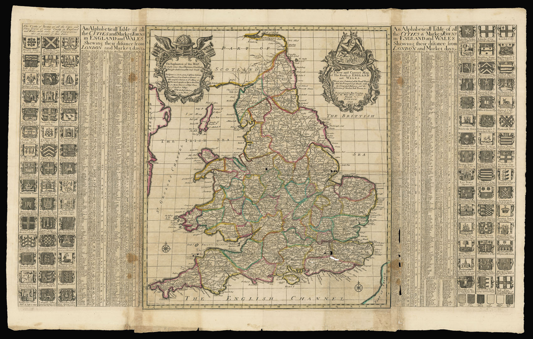
A New and Correct Map of the Roads in England and Wales Wherein are Contained all the Road Waies And the Principal Cross Roads with the Computed Distances and the Distinction of Market Post Towns &c.
- 作者: OVERTON, Henry
- 出版地: London
- 出版商: Printed and Sold by Henry Overton at the White Horse without Newgate
- 发布日期: 1731.
- 物理描述: Engraved map, with fine original outline hand-colour, flanked by an index and 90 coats-of-arms, joined, some minor loss to old folds.
- 方面: (map) 600 by 520mm (23.5 by 20.5 inches). (map and border) 600 by 1015mm (23.5 by 40 inches).
- 库存参考: 12193
笔记
Rare map of the England and Wales.
“The map is dated 1731 but as the engraver, Sutton Nicholls, was not active after 1713 (although he did not die until between 1721 and 1731) the map was probably – although not conclusively – engraved earlier and only reissued as a later state in 1731.
Nicholls has copied, without acknowledgement, Morden and Paske’s similar map of c.1690. The main roads are shown by broad double-lines and the lesser roads by fine double lines. Mileages are marked and the principal harbours are designated by small anchors. The two cartouches are also similar to the earlier map, although on the left, the William and Mary coat of arms, now obsolete, has been replaced by a globe, and on the right by a figure of Mercury. A graticule of lines of latitude and longitude is placed along the central map, not present in the Morden-Paske original”. (Shirley)
Flanking the map is a table of English and Welsh towns showing their distance from London, and market days; together with 90 coats of arms of the shires and towns.
参考书目
- Shirely, British Isles, Overton 8.
相关项目


请注册以了解最新珍品、展览和活动信息
地址
纽约
PO Box 329, Larchmont, NY, USA
开放时间,伦敦画廊
周一至周五:10:00-18:00
周六请预约
公休日:所有银行假日以及 8月1日至31日
营业时间,纽约
仅限预约