 地图
地图  地图集
地图集  珍本
珍本  版画
版画  天文仪器
天文仪器 注册以了解我们最新的收购、展览和活动


地址
纽约
PO Box 329, Larchmont, NY, USA
开放时间,伦敦画廊
周一至周五:10:00-18:00
周六请预约
公休日:所有银行假日以及 8月1日至31日
营业时间,纽约
仅限预约

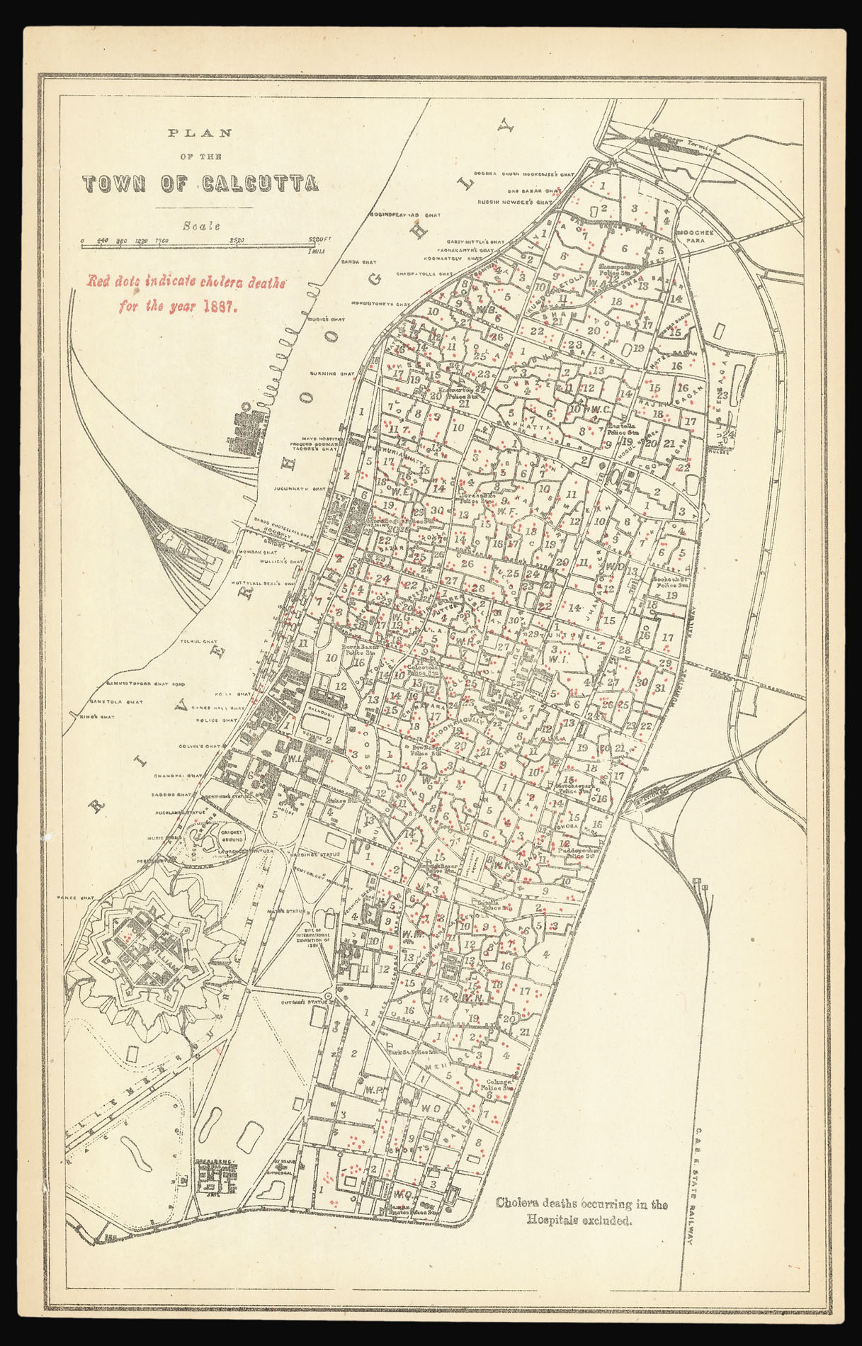

Plan of the Town of Calcutta. Red dots indicate cholera deaths for the year 1887.
- 出版地: [Calcutta
- 发布日期: 1887].
- 物理描述: Chromolithograph plan, cholera deaths marked by red dots.
- 方面: 320 by 205mm. (12.5 by 8 inches).
- 库存参考: 13916
笔记
Rare Cholera map showing the outbreak of the disease across the city of Kolkata in 1887.
The nineteenth century had seen a much greater use of cartography in order to track and chart the spread of infectious diseases, especially cholera, which had seen two pandemics break out between 1817-1824, and 1829-1851. Both cholera pandemics had originated in India, most probably around the Ganges delta. The first pandemic consumed much of Asia, reaching as far as Syria in the west and Japan in the east. The second outbreak spread much further and included much of Russia, Europe, and parts of the Americas. Cholera would throughout the nineteenth century cause more deaths more quickly, than any other epidemic disease. Some three years after the end of the second pandemic, John Snow would publish the second edition of his seminal work: ‘On the Mode of Communication of Cholera’, which incorporated his work on the Soho epidemic (item ).
Cholera was first recorded in Jessore, Bengal, near Kolkata, in 1817. The local conditions were ideal for the epidemic, as the region was densely populated, with a moist, tropical climate, while sanitary conditions were often lax. Cholera lingered around Calcutta constantly throughout the rest of nineteenth Century, occasionally spiking into severe outbreaks. The year 1887 was not an especially bad year for cholera in Calcutta, although, as the map shows, the ‘normal’ situation was still quite grim. A note to the bottom right of the plan states: “cholera deaths occurring in the Hospitals excluded”; their inclusion would have obviously have skewed the overall picture, of the disease generally even spread throughout the city. Kolkata’s medical department worked ceaselessly to stamp out the disease, but did not make transformative headway until the early 20th Century.
The present map was obviously extracted from a medical report or pamphlet, issued in Calcutta, although we have not been able to trace the identity of this publication. Cholera maps printed in India are very rare, and the present map is fine example.
Scale: 2.25 inches to 1 statute mile.
图片库
相关项目


请注册以了解最新珍品、展览和活动信息
地址
纽约
PO Box 329, Larchmont, NY, USA
开放时间,伦敦画廊
周一至周五:10:00-18:00
周六请预约
公休日:所有银行假日以及 8月1日至31日
营业时间,纽约
仅限预约