 地图
地图  地图集
地图集  珍本
珍本  版画
版画  天文仪器
天文仪器 注册以了解我们最新的收购、展览和活动


地址
纽约
PO Box 329, Larchmont, NY, USA
开放时间,伦敦画廊
周一至周五:10:00-18:00
周六请预约
公休日:所有银行假日以及 8月1日至31日
营业时间,纽约
仅限预约

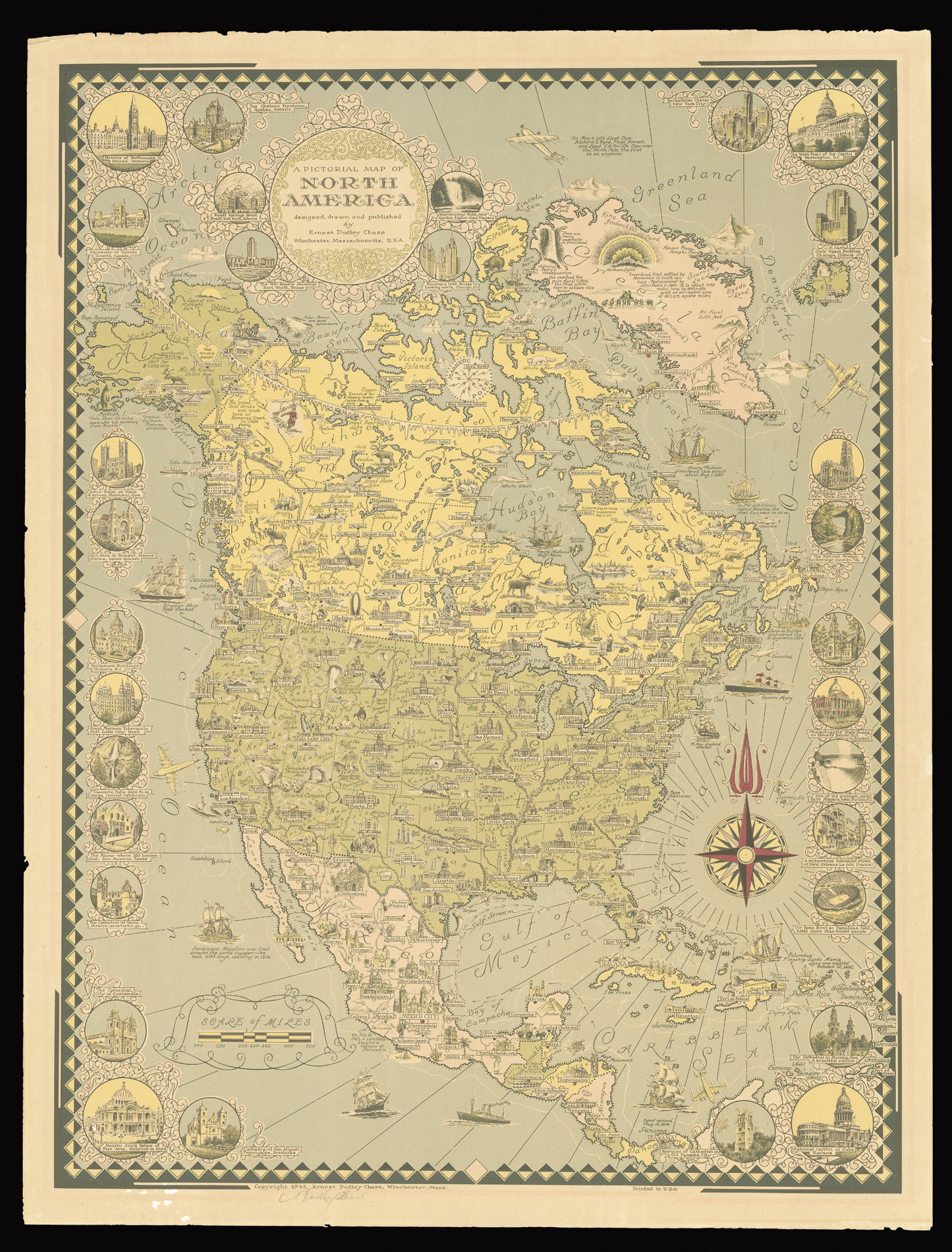
A Pictorial Map of North America designed, drawn and published by Ernest Dudley Chase Winchester Massachusetts, U.S.A.
- 作者: CHASE, Ernest Dudley
- 出版地: Winchester
- 出版商: Ernest Dudley Chase
- 发布日期: 1945
- 物理描述: Chromolithograph map, a few small marginal tears.
- 方面: 690 by 510mm (27.25 by 20 inches).
- 库存参考: 2356
笔记
Dudley Chase’s map of North America stretches from Greenland to the Panama Canal. All major political baoundaries are marked, together with cities, rivers, and prominent landmarks. Other important information includes the settling of Greenland by the Viking’s in the tenth century; the marking of the geogrpahical centre of the U.S.A. at Lebanon, Kansas; and Paricutin in Mexico were on the “Feb. 20, 1943, a cornfield became a volcano”. To the sea are depicted ships ranging from Ferdinand Magellan’s Trinidad, and Columbus’ Santa Maria, to a New England Whaler and the ocean liner the Queen Mary. Surrounding the map are vignettes of American landmarks, including Niagara Falls, the Rockefeller Centre in New York, Capitol Hill, and the Alamo.
Ernest Dudley Chase (1878-1966) was one of the most prolific of the mid-century mapmakers, publishing some fifty maps in the 1930s to the 1960s. His maps cover a broad range of geographical locations and varied topics including historical and current events, architecture, and technology. They typically incorporate large numbers of minutely rendered illustrations with explanatory captions that blend a scholarly approach with wit.
相关项目


请注册以了解最新珍品、展览和活动信息
地址
纽约
PO Box 329, Larchmont, NY, USA
开放时间,伦敦画廊
周一至周五:10:00-18:00
周六请预约
公休日:所有银行假日以及 8月1日至31日
营业时间,纽约
仅限预约