 地图
地图  地图集
地图集  珍本
珍本  版画
版画  天文仪器
天文仪器 注册以了解我们最新的收购、展览和活动


地址
纽约
PO Box 329, Larchmont, NY, USA
开放时间,伦敦画廊
周一至周五:10:00-18:00
周六请预约
公休日:所有银行假日以及 8月1日至31日
营业时间,纽约
仅限预约

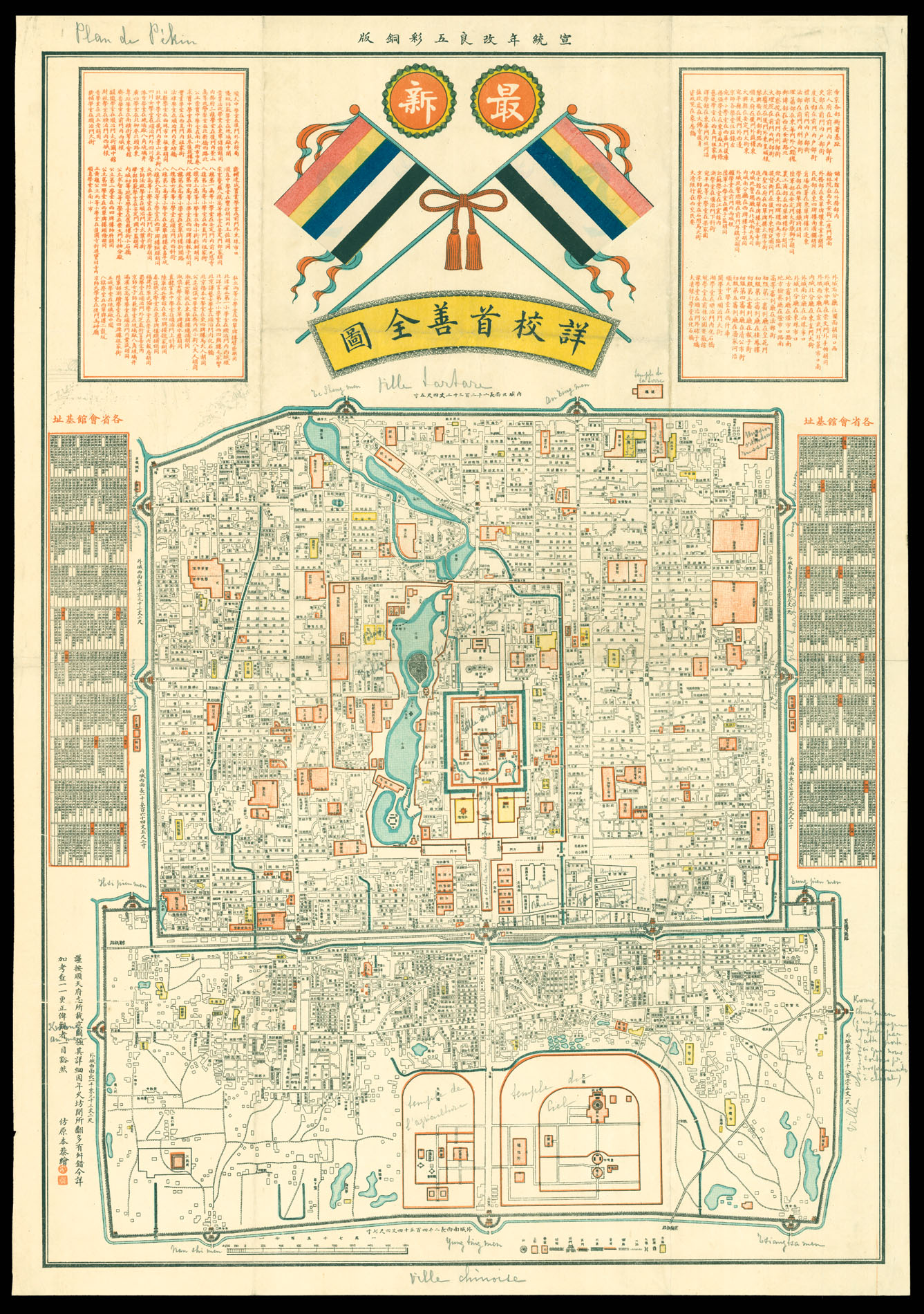
[Map of Peking]
- 物理描述: Lithographed map with original hand colour, manuscript additions in pencil.
- 方面: 735 by 515mm. (29 by 20.25 inches).
- 库存参考: 11846
笔记
A Chinese map of Beijing, with additions in pencil presumably by a French former owner, and possibly a diplomat, given that each of the European embassies near the entrance to the Forbidden City are labelled. The inscriptions identify the Forbidden City (“Ville Interdit”) with two thick lines showing the surrounding wall and moat. The Golden Water River winds across the lower half. The Forbidden City was the Chinese imperial palace and seat of the government for nearly five hundred years. The inscriptions also identify the growth of the city under various ruling dynasties. The narrower upper portion of the city is labelled “ville tartare”, marking the capital built there by the Mongol warlord Kublai Khan, after his grandfather Genghis had razed the previous settlement in 1213. The wider lower portion is labelled “ville chinoise”, and is the product of extensions made by the Lioa and Jin dynasties in the tenth and eleventh centuries, building on the original sixth century Tang dynasty settlement. The Temples of Heaven and Agriculture are outlined in orange in this lower portion.
The handwritten title at the upper left corner reads “Plan de Pekin”, suggesting that the map was made before 1928, when the capital formally reverted to its former name of Beiping. It would become Beijing in 1949 under Chairman Mao.
相关项目


请注册以了解最新珍品、展览和活动信息
地址
纽约
PO Box 329, Larchmont, NY, USA
开放时间,伦敦画廊
周一至周五:10:00-18:00
周六请预约
公休日:所有银行假日以及 8月1日至31日
营业时间,纽约
仅限预约