 地图
地图  地图集
地图集  珍本
珍本  版画
版画  天文仪器
天文仪器 注册以了解我们最新的收购、展览和活动


地址
纽约
PO Box 329, Larchmont, NY, USA
开放时间,伦敦画廊
周一至周五:10:00-18:00
周六请预约
公休日:所有银行假日以及 8月1日至31日
营业时间,纽约
仅限预约

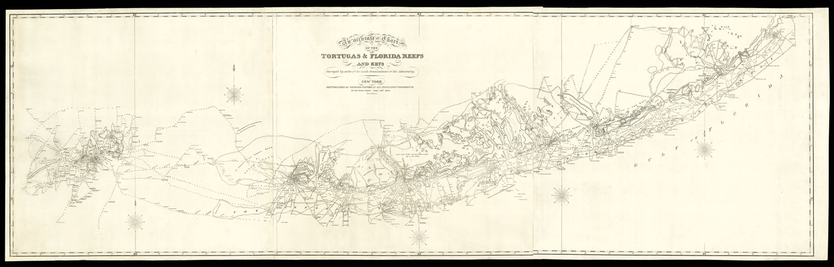
An accurate chart of the Tortugas & Florida Reefs and Keys Surveyed by order of the Lords Commissioners of the Admiralty.
- 作者: GAULD, George.
- 出版地: New York
- 出版商: Republished by Richard Patten at his Navigation Warehouse, No. 180 Water Street.
- 发布日期: June 20th, 1823.
- 物理描述: Engraved map, printed on three sheets, joined. A fine impression.
- 方面: 610 by 2250mm. (24 by 88.5 inches).
- 库存参考: 2263
笔记
Between 1764 and 1781, the Scots surveyor George Gauld (1732-1782) was assigned by the British Admiralty to chart the waters of the Gulf Coast off British West Florida, an area that extended from New Orleans to present-day Florida. In 1773, Gauld submitted his ‘A General Description of the Sea-Coasts, Harbours, Lakes, Rivers etc of the Province of West Florida’, the result of a survey completed in 1769, to the American Philosophical Society, with the hope of having it published in the ‘Transactions’. Whilst Gauld was elected to the Society in 1774, his work was not deemed sufficiently interesting for publication. His manuscript did, however, become one of the first to be entered into the Society’s collections, where it was received with the following notice: “This long uninteresting Paper can hardly obtain a Place in the Transactions of a Philosophical Society. It should however be preserved in the Flies for the Use of Historians or map makers”. but his own writing and chart was not printed until 1790 as An Account of the Surveys of Florida, &c, published by William Faden. Faden’s version of the chart was reprinted in 1847.
Gauld was forced to suspend work on the Dry Tortugas and Florida Keys due to the depredations of American privateers, and was taken prisoner at the siege of Pensacola in 1781. He was then taken to Havana, and released to New York, before being sent to England, where he died shortly afterwards aged fifty.
The present map is a previously unrecorded American version of Gauld’s original. The chart has been completely reengraved, with many stylistic differences, most notably the removal of the coastal profiles and rhumb lines, the moving of the title from the top left to the top center, the omission of detail work on areas of land, and many other cosmetic differences. The coastal details and soundings, however, have been studiously copied from one to the other. Aside from the renaming of what is now the Town of Key West (Port Rodgers) and the island it is on (Thompson’s Island), there are no significant geographic differences between the two maps. The fact that an American version of the chart was made reflects, in the naming of the town and island which would become Key West, the acquisition of Florida by the United States in 1821 and planting of a flag there in 1822. This chart is undoubtedly the first to reflect the name changes which accompanied that acquisition and as such is an important piece in the history of Florida.
We have been unable to trace any other example of this edition. The British Library, and LOC have examples of Faden’s 1790 imprint, and we are aware of a further example in a private collection in Florida.
参考书目
- cf. BLMC Maps K.Mar.VII.43.
相关项目


请注册以了解最新珍品、展览和活动信息
地址
纽约
PO Box 329, Larchmont, NY, USA
开放时间,伦敦画廊
周一至周五:10:00-18:00
周六请预约
公休日:所有银行假日以及 8月1日至31日
营业时间,纽约
仅限预约