 地图
地图  地图集
地图集  珍本
珍本  版画
版画  天文仪器
天文仪器 注册以了解我们最新的收购、展览和活动


地址
纽约
PO Box 329, Larchmont, NY, USA
开放时间,伦敦画廊
周一至周五:10:00-18:00
周六请预约
公休日:所有银行假日以及 8月1日至31日
营业时间,纽约
仅限预约

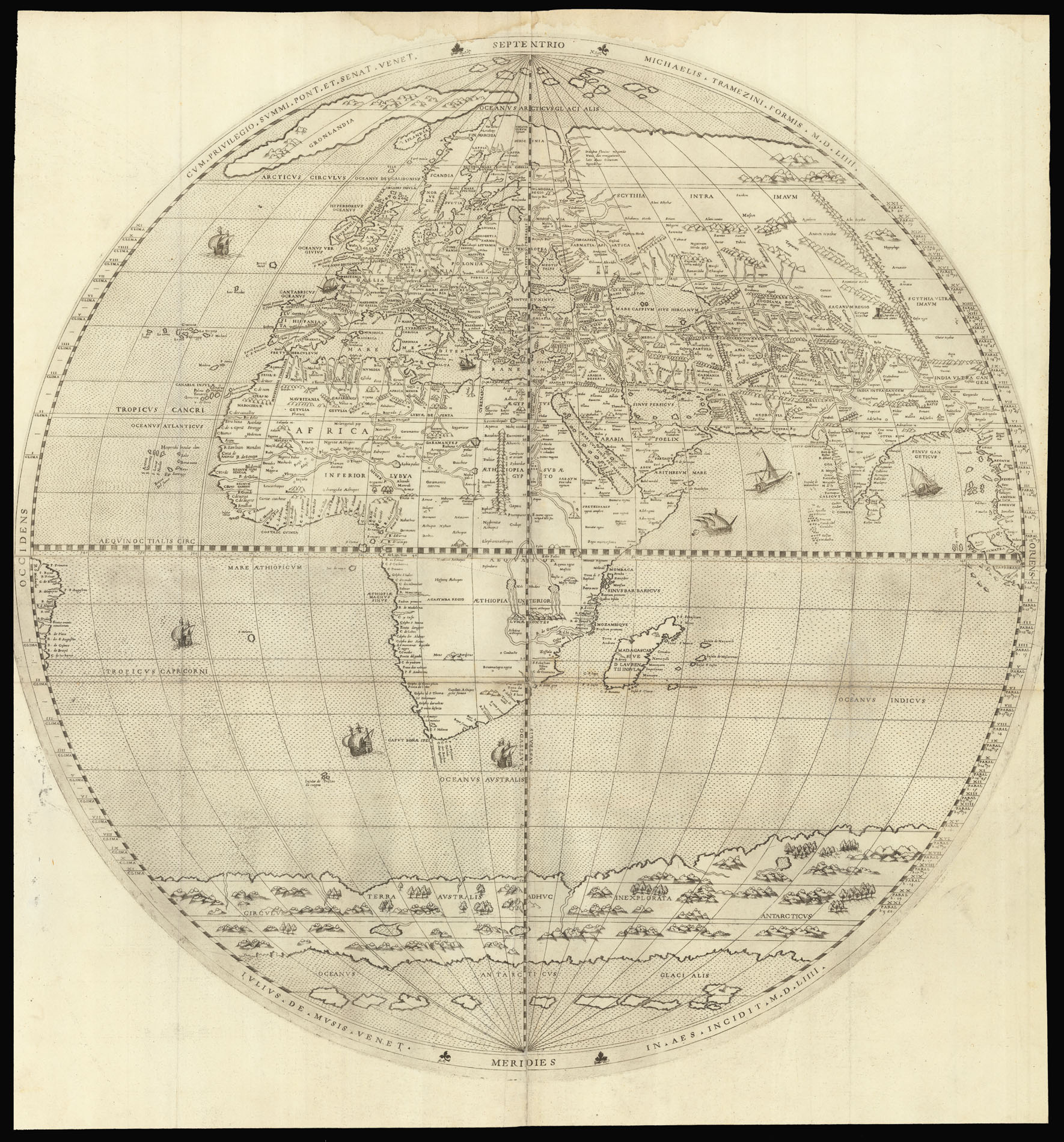

Cum Privelegio Summi Pont et Senat. Venet. Michaelis Tramezini Formis M. D. LIIII Julius De Musis Venet In Aes Incidit M. D. LIIII.
- 作者: TRAMEZZINO, Michele
- 出版地: [Venice or Rome]
- 出版商: Michele Tramezzino
- 发布日期: 1554.
- 物理描述: Engraved map on two sheets, each printed on two copperplates, folds strengthened.
- 方面: 750 by 750mm (29.5 by 29.5 inches).
- 库存参考: 12293
笔记
An exceedingly rare and important map of the two hemispheres, and the single greatest achievement of the publisher Michele Tramezzino.
This large map consists of two hemispheres, each printed from separate copper plates. The hemispheres are upon a ‘homolographic’, or evenly drawn meridian, projection first described by Roger Bacon in the thirteenth century. The map is beautifully engraved by Guilio de’ Musi of Venice, and although both his and the Rome publisher Michele Tramezzino names are mentioned on the work, no cartographer is named.
Although the cartographers name remains a mystery, one can trace the influence of earlier works, and outline a few original features. North America and Asia are separated as in Mercator’s prototype world map of 1538, but details of the west coast and the Calafornian peninsula have been inserted. The serpentine east-west course of the Amazon is prominent, as is the exaggerated estuary of the River Plate: both are features that appeared on Sebastian Cabot’s map of 1544. However, unlike Cabot an extensive southern continent has been added. This is in fact not a complete polar land mass but an extenuated island strip reaching across three-quarters of of the circumference and leaving open sea to the south. In the east, the Moluccas are drawn in detail and a creditable attempt is made to set out the tributaries of the Indus and Ganges, and to mark the northwest and southeast line of the Himalayas. In Africa, the course of the River Niger is shown separate from that of the Nile. The large number of place names round the African and India coasts gives evidence of access to Portuguese sources as well.
Shirley calls it “a masterpiece of Renaissance cartography without any obvious source, or indeed, any imitators.” No later issues or states have been recorded. Shirley estimates that there are only 11 or 12 extant copies, plus a defective copy sold at Christie’s in 2006 (Sale 7350, Lot 4).
参考书目
- Shirley, 97
- BL Maps K. Top.IV.2.
- H.P. Kraus, Catalogue 56, item 21 and Catalogue 80, item 104
- Muller, II 1-4 Nordenskiöld (Periplus) p. 160 and figs. 65-66
- Tooley [18]
- TWE 124 and plate XXXV
- Wagner 31.
图片库
相关项目


请注册以了解最新珍品、展览和活动信息
地址
纽约
PO Box 329, Larchmont, NY, USA
开放时间,伦敦画廊
周一至周五:10:00-18:00
周六请预约
公休日:所有银行假日以及 8月1日至31日
营业时间,纽约
仅限预约