 地图
地图  地图集
地图集  珍本
珍本  版画
版画  天文仪器
天文仪器 注册以了解我们最新的收购、展览和活动


地址
纽约
PO Box 329, Larchmont, NY, USA
开放时间,伦敦画廊
周一至周五:10:00-18:00
周六请预约
公休日:所有银行假日以及 8月1日至31日
营业时间,纽约
仅限预约

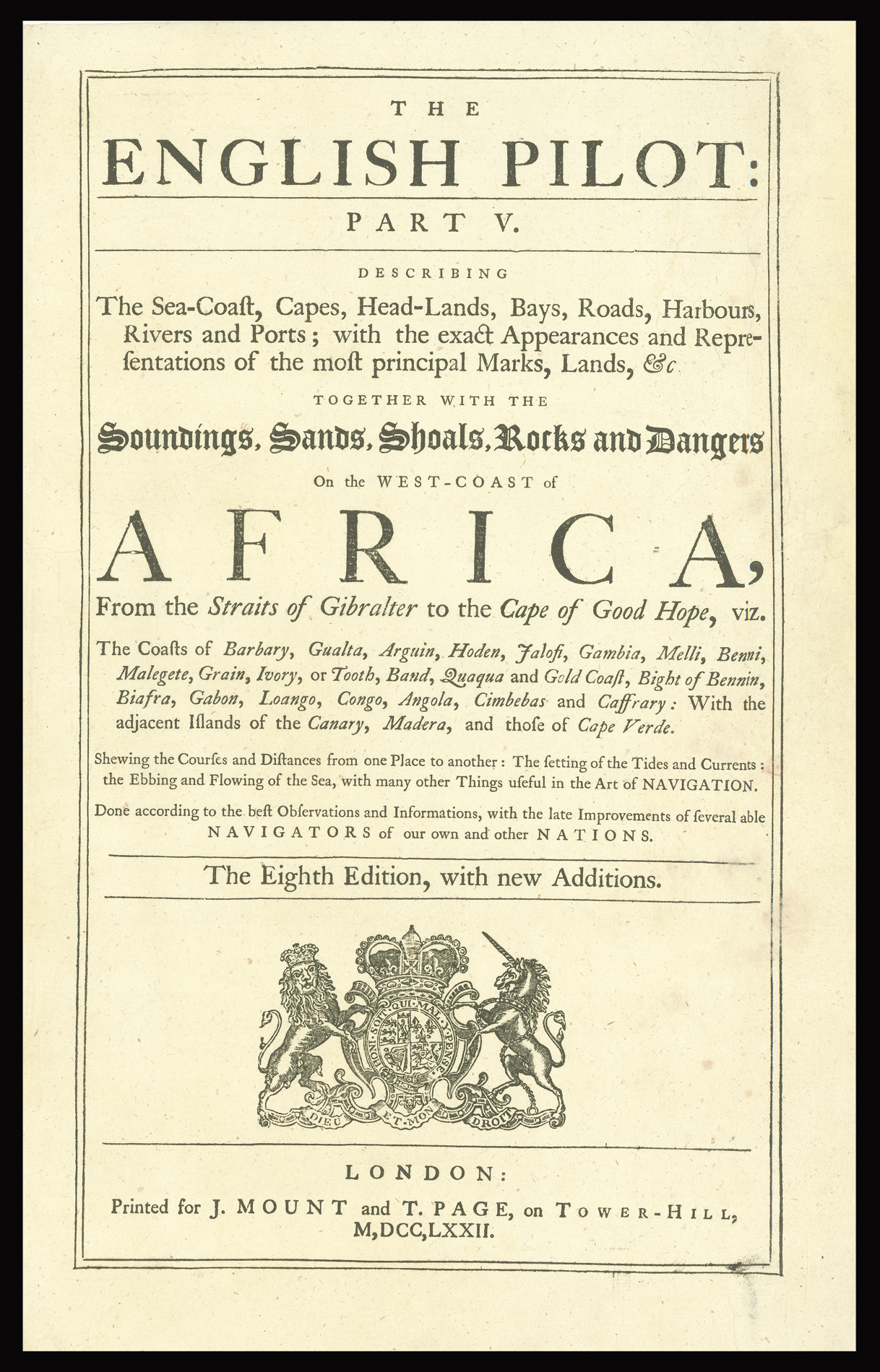


The English Pilot: Part V. Describing the Sea-Coast, Capes, Head-Lands, Bays, Roads, Harbours, Rivers and Ports; with the Exact Appearances and Representations of the most principal Marks, Lands, &c. together with the Soundings, Sands, Shoals, Rocks and Dangers on the coast of Africa… The Eighth Edition with new Additions.
- 作者: SELLER, Jeremiah; and Charles PRICE
- 出版地: London
- 出版商: Printed for J. Mount and T. Page, on Tower Hill
- 发布日期: 1772.
- 物理描述: Folio (450 by 290mm), title 44pp. text, 21 engraved charts on 19 map sheets (chart 11 on two sheets)
- 库存参考: 2984
笔记
The great ‘English Pilot’ project had been started by John Seller in 1671. However, Seller’s financial troubles precluded only publication of the first three parts (Northern, Southern, and Oriental) and it was not until four years after his death, in 1701, that the African or fifth part of the English Pilot was published.
The present Pilot was the work of John Seller’s son Jeremiah Seller, and Charles Price. The first edition contained 15 charts, 12 off which were drawn by Charles Price, with three by the late John Seller. Although the charts were based largely (often copied) from Dutch material, it still constituted the first English marine atlas devoted solely to Africa. Unfortunately, the partnership was not a success, and after the firms loss of the lucrative Naval contract in 1705, they were declared bankrupt in 1707. The works text and plates were brought by the publisher’s Richard Mount and Thomas Page. To confuse matters, John Thornton published a rival edition in 1706. Thornton was part of the consortium that had overseen the publication of the first three parts, and his position as hydrographer to the East India Company meant he had a ready supply of charts of the African coast. Following the death of John Thorton’s son Samuel in 1715, his stock was acquired by Mount and Page.
Mount and Page would issue a new edition in 1716, which amalgamated the Seller, and Thornton charts and would continue to issue the pilot with a minimum amount revision to the charts and text until 1780.
The present work is eight edition published by the firm in 1772. Of the 21 charts 14 are by Jeremiah and Charles Price; three after after Smith and engraved by Grey; one by John Thornton; two by Samuel Thornton, and one by Mount and Page. All but the chart by Mount and Page have had their imprint removed.
We are unable to trace any institutional examples of the present edition.
Collation
1. MOUNT, John & PAGE, Thomas. A Chart of the Sea Coast from England to the Streights Sold by Jno. Mount & Thos. Page at Postern Row on Tower Hill. [Inset of Cadiz].
2. [SELLER, Jeremiah, PRICE, Charles] The Western Ocean.
3. [SELLER, Jeremiah, PRICE, Charles] A Chart of the Coast of Barbary from C. Spartell to C. Cantin.
4. (a) [SELLER, Jeremiah, PRICE, Charles] A Chart of ye Coast of Barbary from C. Bajadore to the Golfe of St. Anne.
(b) [SELLER, Jeremiah, PRICE, Charles] A Chart of ye Coast of Barbary from Cape Geer to Cape Bajadore.
5. PRICE, Charles. A Correct Chart of the Coast of Portugal & Barbaria… Humbly dedicated to Robert Godscall of Weston Esqr. by His Obliged Servant C. Price. [Inset of Gallicia and Lisbon Harbour].
6. [SELLER, Jeremiah, PRICE, Charles] A New Chart of the Coast of Arguin from ye Gulf of St Anna to the sand bank of Tindel.
7. [THORTON, John] New Mapp of ye Coast of Guinea from Cape de Verd to Cape Bona Esperanca.
8. [SMITH]
(a) An Exact Map of ye River Sierra Leone and ye Coast from thence to Sherbro.
(b) [Mouth of the River Gambia].
(c) An exact Map of the River Sherbro.
9. [SELLER, Jeremiah, PRICE, Charles] A Chart of the Shoulds & Rivers of Gambia.
10. [THORTON, Samuel] A Large Chart of the North Coast of Guinea from Cape de Verd to Sherbro.
11. [THORTON, Samuel] A Large Chart of the Coast of Guinea From Sherbro to Cape Lopas.
12. [SELLER, Jeremiah, PRICE, Charles] Chart of the Grain, Ivory, & Quaqua Coast in Guinea. From Cape St. Anne to Teen Pequene.
13. [SELLER, Jeremiah, PRICE, Charles] A Chart of the Gold Coast in Guinea From the River St John to the River Volta.
14. [SELLER, Jeremiah; PRICE, Charles] A Chart of the Bight of Binnin from Ningo Grande to R. Andony.
15. [SELLER, Jeremiah, PRICE, Charles] A Chart of ye Coast of Biafra from Foche Island to Corisco Island together with the Islands of Fernando Poo & Princes.
16. [SELLER, Jeremiah, PRICE, Charles] A Chart of ye Coasts of Gabon, Loango, and Congo, from the C. St John to the River Ambris.
17. [SELLER, Jeremiah, PRICE, Charles] A Chart of ye Coast of Angola from ye R. Ambris to Mount Negro.
18. [SELLER, Jeremiah, PRICE, Charles] A Chart of ye Coast of Cimbebas and Caffaria from Mt. Negro to ye C. of Good Hope. Inset of Table Bay.
参考书目
- C.f. NMM 3.428 for 1761 edition.
图片库
相关项目


请注册以了解最新珍品、展览和活动信息
地址
纽约
PO Box 329, Larchmont, NY, USA
开放时间,伦敦画廊
周一至周五:10:00-18:00
周六请预约
公休日:所有银行假日以及 8月1日至31日
营业时间,纽约
仅限预约