 地图
地图  地图集
地图集  珍本
珍本  版画
版画  天文仪器
天文仪器 注册以了解我们最新的收购、展览和活动


地址
纽约
PO Box 329, Larchmont, NY, USA
开放时间,伦敦画廊
周一至周五:10:00-18:00
周六请预约
公休日:所有银行假日以及 8月1日至31日
营业时间,纽约
仅限预约


Cosmographiae universalis Lib. VI. Auctore Sebast. Munstero.
- 作者: MÜNSTER, Sebastian
- 出版地: Basel
- 出版商: Henrichum Petri
- 发布日期: 1550.
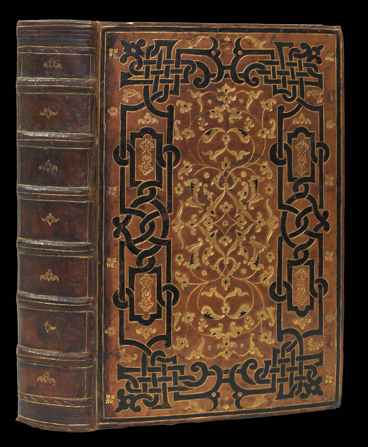
- 物理描述: Folio (328 by 210mm), 623pp., incorporating a total of 120 woodcut maps and views, 34 of which are double-page and three of which are folding panoramas, minor marginal loss to one leaf, large closed tear to panorama of Vienna, some leaves with closed tears, contemporary French calf over wooden boards, gold tooled strapwork border, painted black, elaborate central foliate piece, lavishly gilt, spine in seven compartments separated by raised bands, gilt ruled, each compartment containing a gilt floral motif, a.e.g., gauffered edges.
Collation: 2, 3, 4, [2], *1-6, a-z8, A-B8, C6, D2, E8,F6, G4, H2, I4, K2, L4, M2, N-O8, P6, Q2, R2, S4, T2, V2, X4, Y4, Z6, Aa-Bb2, Cc8, Dd2, Ee-Gg8, Hh4, Ii8, Kk6, Ll2, Mm4, Nn-Oo8, Pp4, Qq, Rr4, Ss2, Tt4, Vu6, Xx4, Yy2, Zz8, AA-BB2, CC8, DD4, EE8, FF8, GG4, HH-KK8, LL4, MM-QQ8, RR4, SS-ZZ8, Aaa- Fff8, Ggg-Hhh6. - 库存参考: 11840
笔记
A magnificent example of Sebastian Münster’s ‘Cosmographia’, a work containing a trio of cartographic innovations: the first separate printed map of the Western Hemisphere; the first “set” of maps of the four continents; and the first printed map to name the Pacific Ocean.
The cartography
The ‘Cosmographia’ contains the first set of maps of the four continents, which Münster produced for his edition of Ptolemy’s ‘Geographia’ in 1540. While individual continents had been mapped in print before 1540 (Africa in Montalboddo’s ‘Itinerarium Portugallesium’, 1508; Europe by Waldseemüller, 1511; America by Stobniza, 1512; Asia in Münster’s edition of Solinus, 1538), Münster was the first to publish a coherent set. They are famous for their decorative elements: Magellan’s ship, the ‘Victoria’, is visible on the map of the Americas; the “monoculi” (or cyclops) on the map of Africa; the shipwreck of St Paul on the second map of Africa; and the elephant on the map of Ceylon. The map of Europe is, unusually, oriented to the south.
Coming half a century after Columbus’s initial landfall in the Indies, Münster’s map of America is the first separate printed map of the Western Hemisphere. Two decades after Magellan’s circumnavigation,
it is also the first printed map (along with Münster’s world map) to refer to Magellan’s great ocean by the name he had christened it: Mare Pacificum. Also of note is the strange constriction of the North American land mass towards the top of the continent. This is the first printed result of the confusion resulting from Giovanni da Verrazano’s report of the sighting of a ship in a body of water on the other side of an isthmus. Verrazano’s isthmus was, in reality, nothing more than the Outer Banks between Cape Lookout and Cape Henry; his Oriental Sea, which he thought would lead to the blessed shores of Cathay (China) was, in fact, the Pamlico and Albermarle Sounds. In the northeast, Münster has labelled Francisca (Canada), named by Verrazano after Francis I, shortly before his return to Europe.
Münster has inserted a Spanish and a Portuguese standard in the Atlantic Ocean, intended to reflect the division of the unknown world in two by the Papal Treaty of Tordesillas (1494). Japan (“Zipangri”) appears as a large rectangular island off the “California” coast. The map was created two or three years before Europeans first landed there; it was known only from the writings of Marco Polo. Marco Polo was also the source for Münster’s belief in the complex of 7,448 islands between Japan and the Asian mainland. As with Japan, Polo himself never ventured there, but by their number and the description of them given to Polo by his hosts, it is likely that these islands were the Philippines. By Münster’s time, direct European contact with the Philippines had been made, both by Magellan (who died there) and almost certainly by eastward-bound Portuguese explorers before him. Münster included the real Philippine island of Puloan on his map of Asia. It was both this exaggerated archipelago and European underestimation of the Pacific’s true size that pushed Japan so close to North America on Münster’s map. A large illustration of Magellan’s ship and the so-called Unfortunate Islands are shown below Japan, named because Magellan’s expedition was unable to anchor at either of them on their difficult journey home. Their luckless path across the Pacific bypassed, though barely, islands of the Polynesian groups; the islands’ resources would have spared them scurvy and starvation. Disease, violence, and malnutrition took the lives of all but 18 of the 277 members of the expedition. The map of Africa also contains many curious features: a one-eyed giant seated over Nigeria and Cameroon, representing the mythical tribe of the “monoculi”; a dense forest located in today’s Sahara Desert; and an elephant filling southern Africa. The Niger River begins and ends in lakes. The source of the Nile lies in two lakes fed by waters from the fabled Mountains of the Moon, graphically presented as small mounds. Several kingdoms are noted, including that of the legendary Prester John, as well as “Meroë”, the mythical tombs of the Nubian kings. Few coastal towns are shown, and there is no sign of the vast island of Madagascar. A simplified caravel, similar to those used by the Portuguese (and Columbus), sails off the southern coast. One of the intriguing aspects of this map is the loop of the Senegal River, which is shown entering the ocean in today’s Gulf of Guinea. Actually, this is the true route of the Niger River, but that fact would not be confirmed until the Lander brothers’ expedition in 1830. Strangely, this loop disappeared from subsequent maps of Africa for the following two hundred years.
A further interesting feature of the work is the plate of monsters of both land and sea, taken from Olaus Magnus’s ‘Carta Marina’ of 1539, with abundant tusks, horns and twin-spouts. One vignette shows a galleon trying to outrun a monster by throwing their cargo overboard, while one sailor takes sight with a musket. Ortelius adapted many of these monsters for use on his map of Iceland in 1587.
The mapmaker
Sebastian Münster (1488-1552) was a cosmographer, humanist, theologian, and linguist. He was famous in his own age as a Hebraist, composing a grammar and a list of Hebrew, Latin, and Greek synonyms which were used widely by contemporary scholars. After entering the Franciscan order around 1506, Münster studied in Tübingen and taught in Basel and Heidelberg before leaving the order and moving to Basel in 1529, where he took up the chair in Hebrew. Whilst in Basel, Münster indulged in his other great love: that of cartography. The love affair had begun some years earlier in Tübingen under the tutelage of Johann Stöffler. Münster’s notebook of the time contains some 43 manuscript maps, most of which were based upon others’ work, except for a map of the Rhine from Basel to Neuss.
Münster would produce his first map in a printed broadsheet of 1525. The map, which covers Germany, also came with an explanatory text (only extant in the second edition of 1528), which lays out Münster’s vision for a new great survey of Germany. He readily conceded that the job was too great for one man and so called upon fellow academics to cooperate and supply detailed maps of and texts about their respective areas, with Münster working as the great synthesiser. Although the project would never get off the ground, much of its methodology and material would be used, with great success, in his ‘Cosmographia’.
In 1544, Münster produced his greatest work, the ‘Cosmographia’. It was the culmination of a lifetime’s study, in which he distilled the geographical information he had gathered over the past 30 years. Münster organised the work in a series of periegeses, or geographical travels. He began by describing an area’s geography, history, ethnography, flora and fauna. He would, famously, then relate tales of strange peoples, fabulous plants, and wondrous events. The work would prove to be so popular that some 40 editions were published between 1544 and 1628, with the number of maps expanding from 26 in the 1544 edition to 262 by 1628. Its huge popularity would not only “seal the fate of America as the name of the New World” (Burden), but would form the basis of general knowledge of many other parts of the world as well.
The binding
The shape of some of the tools used can be matched with those of the royal binder Claude Picques (Nixon). Many of the tools are hatched and Mirjam Foot has noted in her introduction to the third volume of the catalogue of the Henry Davis Gift that some of the hatched tools formerly attributed to Picques may now be attributed to Gommar Estienne, his predecessor. It seems likely, therefore, that it was made or finished by a French royal binder, who also worked on Grolier books.
The present copy is a fine example of the fifth Latin edition of this work, complete with all maps and views, in a spectacular binding. This edition was the last one published fully under the supervision of Münster before his death in 1552 from the plague. We can only trace three examples of this edition at auction in the last 75 years, at least one of which was incomplete.
参考书目
- Mickwitz, Nordenskiöld, 153
- Sabin 51390
- Shirley, British Library, T.MUN-1h.
- Philip D. Burden, The Mapping of North America: A List of Printed Maps, 1511-1670 (Rickmansworth: Raleigh, 1996)
- K.H. Burmeister, Sebastian Münster: Eine Bibliographie (Wiesbaden, 1964)
- H.M. Nixon, Bookbindings from the collection of Jean Grolier' (London: British Museum, 1965)
- R. Oehme, introduction to Cosmographiae universalis: facsimile of the 1550 edition of Münster's Cosmographia (Amsterdam: Theatrum Orbis Terrarum, 1968)
- H.L. Ruland, "A survey of the double page maps in thirty five editions of the Cosmographia Universalis 1544-1628 of Sebastian Münster and his editions of Ptolemy's Geographia 1540-1552", Imago Mundi 16 (1962), 84-97
图片库
相关项目


请注册以了解最新珍品、展览和活动信息
地址
纽约
PO Box 329, Larchmont, NY, USA
开放时间,伦敦画廊
周一至周五:10:00-18:00
周六请预约
公休日:所有银行假日以及 8月1日至31日
营业时间,纽约
仅限预约