 地图
地图  地图集
地图集  珍本
珍本  版画
版画  天文仪器
天文仪器 注册以了解我们最新的收购、展览和活动


地址
纽约
PO Box 329, Larchmont, NY, USA
开放时间,伦敦画廊
周一至周五:10:00-18:00
周六请预约
公休日:所有银行假日以及 8月1日至31日
营业时间,纽约
仅限预约


Geographicae Enarrationis, Libri Octo. Ex Bilibaldi Pircheymheri tralatione, sed ad Graeca & Prisca exemplaria a Michaele Villanovan (d.i. Servertus) secondo recogniti, & locis innumeris denuo castigati.
- 作者: PTOLEMAEUS, Claudius; and Michael VILLANOVANUS, known as 'SERVETUS'
- 出版地: Prostant Lugduni
- 出版商: apud Hugonem a Porta
- 发布日期: 1541.
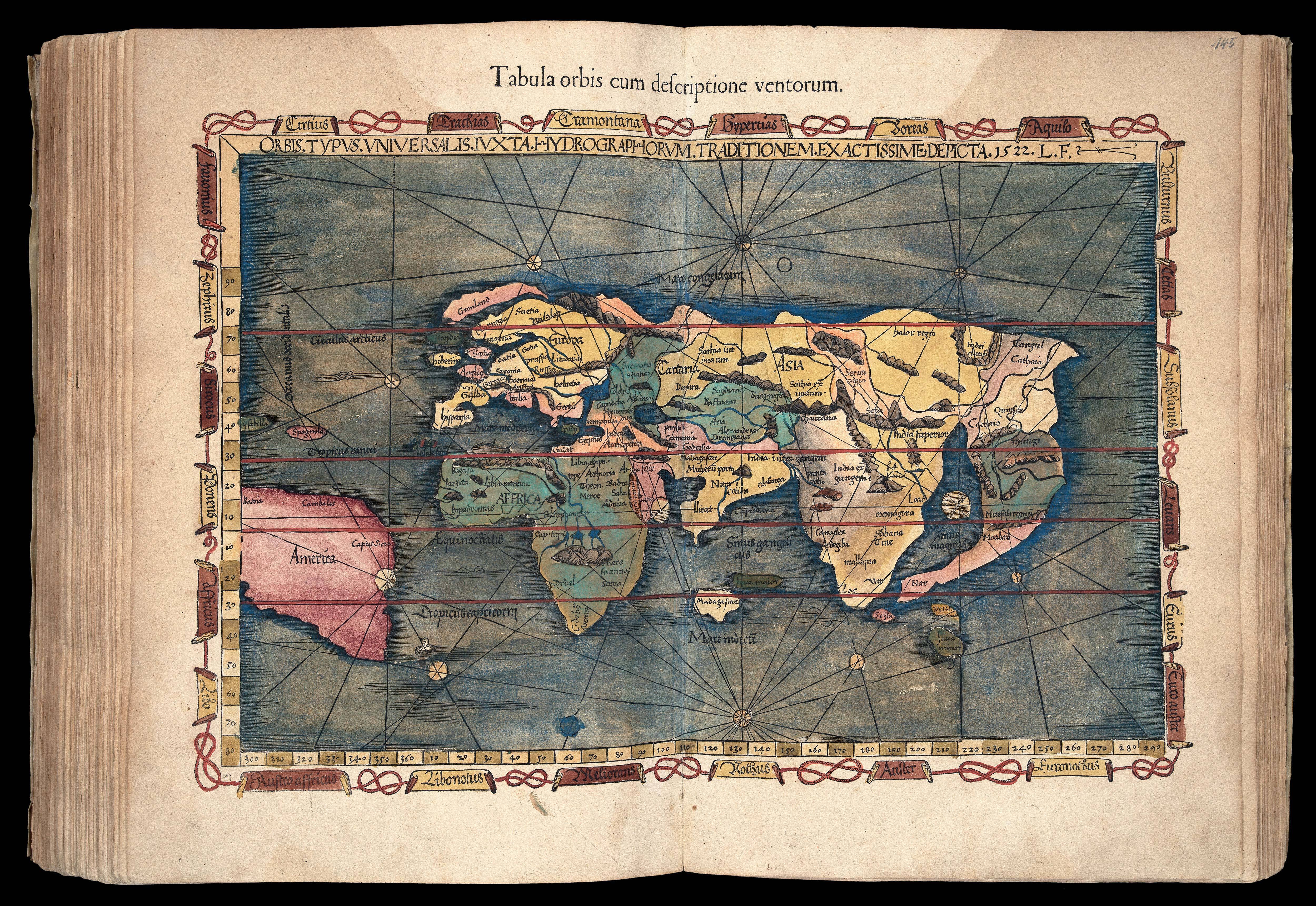
- 物理描述: Folio. Large woodcut printer's device on title-page; double-page woodcut old map of the world, 26 old regional maps, 2 modern maps of the world, 20 new regional maps and one full-page, most with text enclosed in elaborate woodcut borders, probably by Hans Holbein and Urs Graf, text with 2 full-page woodcuts of a diagram and armillary sphere showing the projection of the winds by Albrecht Dürer (l4 verso), all with magnificent contemporary hand-colour in full, 4 large woodcut diagrams, woodcut initials, colophon n4 present, seventeenth-century limp vellum, recased.
Collation: a-i(6), k-m(6), n(4), 50 maps, A-G(6), 2[-]; pp., [1]-149, [3], 50 maps, [76]. - 方面: 405 by 285mm. (16 by 11.25 inches).
- 库存参考: 14936
笔记
Beautifully coloured in a contemporary hand throughout, and very rare as such, this is the second edition of Ptolemy’s ‘Geographia’ to be edited by Michael Villanovanus, better known as Servetus, (c1490-1570). It was printed by Gaspar Trechsel for Hugues de la Porte (1500-1572) in Lyon, a well-known protestant publisher and bookseller, and a prominent member of the Grande Compagnie des Libraries de Lyon (founded in 1519), many of whose works were on the list of condemned books, some of which were destroyed on the banks of the Saone by order of the Archbishop in 1568 (Davis).
Nevertheless, the most inflammatory remarks from the earlier editions of the text have been removed. While working as an editor for the publishers Melchior (c1490-1570) and Gaspar Trechsel, Servetus, who was born at Villanueva, in Aragon, Spain, wrote the preface and many of the descriptions for the versos of these maps, for an edition which was first published in 1535. He unwittingly translated verbatim the text accompanying map 41, ‘Tab. Ter. Sanctae’, of the Holy Land, from the 1522 and 1525 editions, in which it states that Palestine “was not such a fertile land as was generally believed, since modern travellers reported it barren”. Excising the offensive text for this new edition did not save Servetus, when he was burnt at the stake in 1553, this heresy was charged to him, along with 39 other counts, which included the sins of writing against the Holy Trinity and infant baptism. As a result, many copies of the book were burned with him on the orders of John Calvin.
The maps, which are very rarely found with such fine contemporary colour, as here, include 27 depicting the ancient world, 22 of the modern world, and one of Lotharingia. They are printed from the same woodblocks that were created by Laurent Fries for the 1522 edition of Ptolemy’s ‘Geographia’, after the original 1513 maps of Martin Waldseemuller (1470-1520). Fries was originally a physician, “at a succession of places in the Alsace region, with a short spell in Switzerland, before settling in Strasbourg, in about 1519. By this time, he had established a reputation as a writer on medical topics, with several publications already to his credit. Indeed, it was thus that Fries met the Strasbourg printer and publisher Johann Grüninger, an associate of the St. Die group of scholars formed by, among others, Walter Lud, Martin Ringmann and Martin Waldseemuller. It would seem that Gruninger was responsible for printing several of the maps prepared by Waldseemuller, and for supervising the cutting of the maps for the 1513 edition of Ptolemy, edited by the group.
Three of the maps relate to the Americas: ‘Terra Nova’, the first map in an atlas dedicated to America; ‘Tabula noua totius orbis’, to which he added images of Russian, Egyptian, Etheopian, Trapobanan and Mursulian kings, and an elephant off the coast of Greenland; and ‘Orbis typus universalis’, the ‘Admiral’s map’, and the first map in an atlas to name America’.
Albrecht Durer (1471-1528) created his image of the armillary sphere for the Gruninger edition of Ptolemy’s Geography, 1525. His simple and elegant rendition of the inhabited parts of the globe, within the floating spherical astrolabe, is less a scientific instrument and more a framework for the schematized world; belying the complex nature of Ptolemy’s text.
参考书目
- Alden & Landis 541/9
- Burden 4
- Phillips Atlases 366
- Sabin 66485
- Shirley 47-49.
- Davis 'On the Protestantism of Benoit Rigaud', 1955, page 246
图片库
相关项目


请注册以了解最新珍品、展览和活动信息
地址
纽约
PO Box 329, Larchmont, NY, USA
开放时间,伦敦画廊
周一至周五:10:00-18:00
周六请预约
公休日:所有银行假日以及 8月1日至31日
营业时间,纽约
仅限预约