 Rare Maps
  Rare Atlases
  Rare Books
  Rare Prints
  Globes and Planetaria
 Sign up to hear about our latest acquisitions, exhibitions and events


Find Us
New York
PO Box 329, Larchmont, NY, USA
Opening hours, London Gallery
Monday to Friday: 10:00 – 18:00
Saturday: by appointment
Closed: all bank holidays and 1-31 August
Opening hours, New York
By appointment only
Opening hours

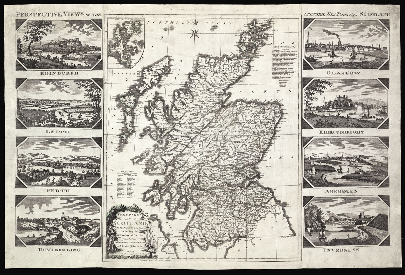
Thompson's Map of Scotland with the Seaports and Views including the New Roads & Canals ordered by the Parliamentary Commissioners, with the Post Officers &c. &c.
- Author: THOMPSON, G[eorge]
- Publication place: London
- Publisher: G. Thompson, 43 Long Lane, West Smithfield
- Publication date: Nov. 1807.
- Physical description: Engraved map, hand-coloured in outline, border to left and right consisting of eight views of Scotland's principal ports.
- Dimensions: 650 by 995mm (25.5 by 39.25 inches).
- Inventory reference: 12797
Notes
Fine and large map of Scotland, with views of the principal ports.
Thompson’s has used Ainslie’s map of Scotland – first published in 1789 – the most accurate map at the time. To this Thompson has updated it with the latest roads canals, and post offices. To the right above the title is a list of Scottish counties, and to the upper right a list of royal boroughs, and Scottish universities. To the left and right of the map are two pasted borders, depicting eight views of Scotland’s principal ports: Edinburgh, Leith, Perth, Dunfermline, Glasgow, Kirkcudbright, Aberdeen, and Inverness.
George Thompson (1758-1826) was a letterpress printer, engraver, mapseller, bookseller and publisher. He is known to have published several maps, however, the present work is not mentioned in the Moir, Baynton-Williams and Worms, or the NLS online catalogue. In fact we are unable to trace any institutional example of the present work.
Bibliography
- Not in Moir
- Not traced in the NLS
- Not listed in Baynton-Williams & Worms, British Map Engravers.
Related items


Sign up to hear about our latest acquisitions, exhibitions and events
Find Us
New York
PO Box 329, Larchmont, NY, USA
Opening hours, London Gallery
Monday to Friday: 10:00 – 18:00
Saturday: by appointment
Closed: all bank holidays and 1-31 August
Opening hours, New York
By appointment only