 Rare Maps
  Rare Atlases
  Rare Books
  Rare Prints
  Globes and Planetaria
 Sign up to hear about our latest acquisitions, exhibitions and events


Find Us
New York
PO Box 329, Larchmont, NY, USA
Opening hours, London Gallery
Monday to Friday: 10:00 – 18:00
Saturday: by appointment
Closed: all bank holidays and 1-31 August
Opening hours, New York
By appointment only
Opening hours

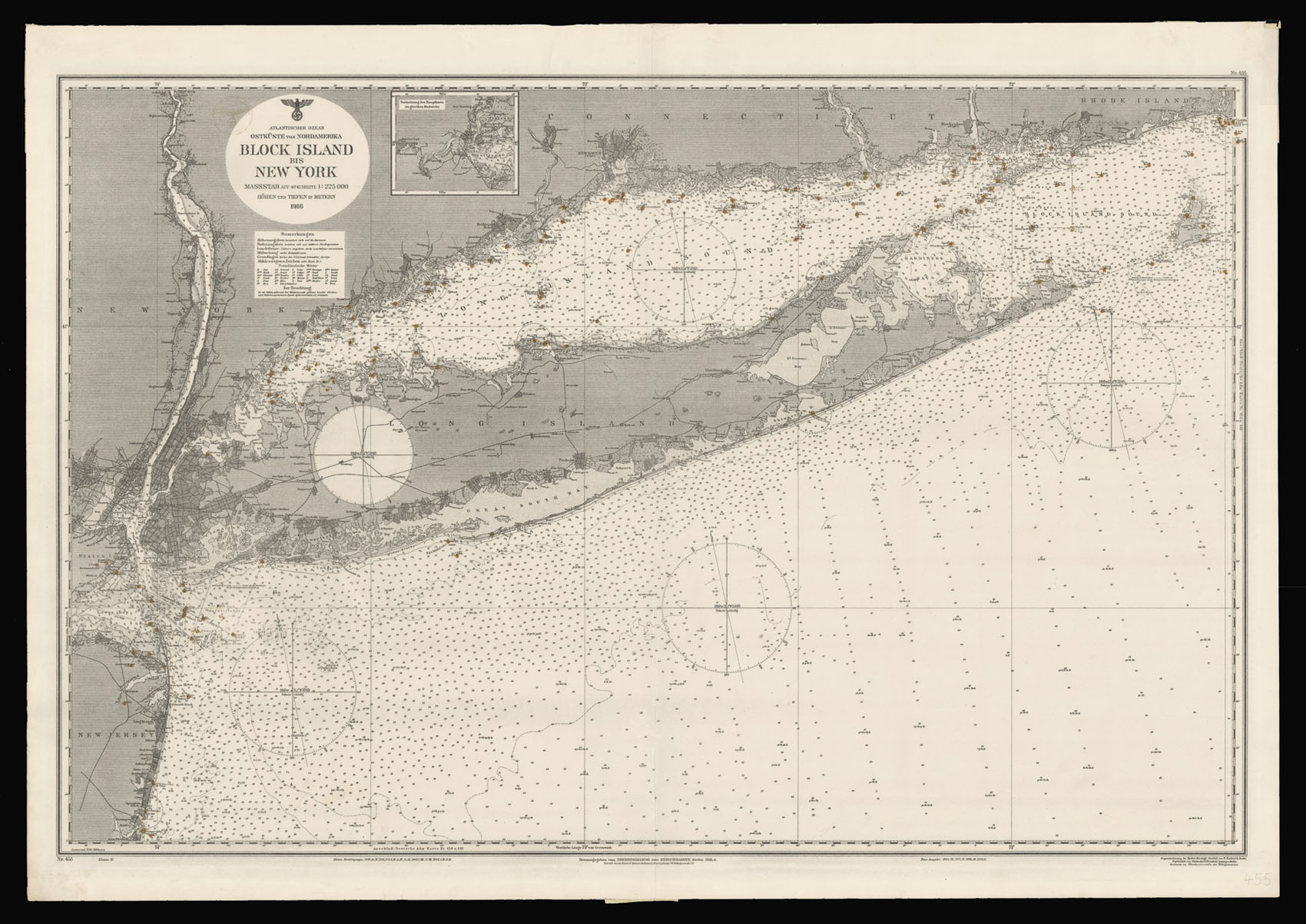
Atlantischer Ozean Ostkuste von Nordamerica Block Island bis New York. Masstab auf 40o 45′ Breite 1: 225 000 Hohen und Tiefen in Metern 1916.
- Author: KRIEGSMARINE; and Richard ENDERLICH
- Publication place: Berlin
- Publisher: Originalzeichnung der Hydro-Kartogr. Anstalt von R. Enderich; Kupferstich von Giesecke & Devrient, Leipzig u Berlin. Gedruckt im Oberkommando der Kriegsmarine
- Publication date: 18th March, 1942.
- Physical description:
Lithographed chart, heightened with original hand-colour.
- Dimensions: 765 by 1110mm. (30 by 43.75 inches); 650 by 1050mm to the neatline.
- Inventory reference: 15970
Notes
Price $190,000 — sold as a collection.
Detailed German hydrographical chart (number 455, Klasse IV) of Long Island, with the coastlines of New York extending inland to Cold Spring on the Hudson River; south to Point Pleasant, New Jersey; east to Pt. Judith in Rhode Island. With an inset map of Raritan Bay and part of Staten Island. Lighthouses, harbor lights, and channel lights are heightened by hand in yellow wash; relief shown by spot heights, form lines and hachures; depths shown by soundings and isolines.
First issued by the Herausgegeben von Oberkommando der Kriegsmarine, Berlin, in September of 1916, with new editions published in 1923, and 1940; this example was reissued in March of 1943. The Kreigsmarine, the German wartime equivalent of the British Admiralty, and the U.S. Geographical Survey produced a comprehensive series of maps of the coastlines of the world. This particular map of Long Island and the approaches to Manhattan is particularly rare, with only one institutional example found: at the Beinecke, Yale.
During World War I, the Germans had led a successful attack on the munitions warehouses of Black Tom Island, near Jersey City, when saboteurs set off an explosion on July 30th, 1916, which registered 5.5 on the Richter scale, killing five people, “jostling the Brooklyn Bridge, shattering plate-glass windows six miles away and shaking building foundations in five states” (NYTimes online).
Twenty-six years later, once the US had officially entered WWII, after the Japanese attack on Pearl Harbour, the Germans tried again. Operation Pastorius, planned for June of 1942, and carried out by longtime German residents of the US, included among its targets Hell Gate Bridge in New York and Pennsylvania Station in Newark, New Jersey. Four saboteurs came ashore at Amagansett, Long Island, on the night of June 12th, 1942, brought there by U-Boat 202. One of their number was discovered, and the munitions and other equipment he had buried in the dunes, seized. When the same operative gave himself up to the FBI the mission came to nothing.
In the wake of the failure of Operation Pastorius, two more German spies were landed at Frenchman Bay in the Gulf of Maine by U-Boat 1230, as part of Operation Elster, purportedly to gather intelligence on the Manhattan Project, to sabotage it, and gather what other information they could on shipyards, airplane factories, and rocket-testing facilities.
Rare: no examples appear in auction records; only one institutional example, at the Beinecke Library, Yale.
Provenance
with the ink stamp of the Third Reich upper left.
Related items


Sign up to hear about our latest acquisitions, exhibitions and events
Find Us
New York
PO Box 329, Larchmont, NY, USA
Opening hours, London Gallery
Monday to Friday: 10:00 – 18:00
Saturday: by appointment
Closed: all bank holidays and 1-31 August
Opening hours, New York
By appointment only