 Rare Maps
  Rare Atlases
  Rare Books
  Rare Prints
  Globes and Planetaria
 Sign up to hear about our latest acquisitions, exhibitions and events


Find Us
New York
PO Box 329, Larchmont, NY, USA
Opening hours, London Gallery
Monday to Friday: 10:00 – 18:00
Saturday: by appointment
Closed: all bank holidays and 1-31 August
Opening hours, New York
By appointment only
Opening hours

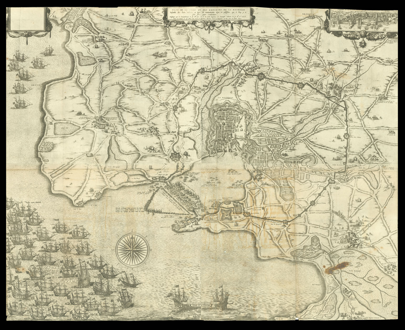
Plan de la Ville et des Environs de La Rochelle Ensemble des Fortes redoutes et lignes de communications digue et palissades que le Roy y a fait faire pour lenuironner. Dessigné par le Commandement de sa M[ajes]te. par le Sr. du Carlo Ingenieur ordinaire de sa M[ajes]te. A[nn]o. 1628. Acheue de Grauer le 29me. May Lan 1628 per Melchior Tauernier Graueur et imprimeur du Roy pour les Tailles douces
- Author: CARLO, du
- Publication place: Paris
- Publisher: Melchior Tavernier
- Publication date: 1628.
- Physical description: Engraved map on four sheets joined.
- Dimensions: 1080 by 960mm. (42.5 by 37.75 inches).
- Inventory reference: 11357
Notes
A birds-eye plan of the siege, taken from an imaginary viewpoint above Fort de Bonnegraine, focusing on the naval events. The harbour mouth is blocked by a line of French ships and a barrier, to keep the English out, while the French fleet is depicted in the lower left corner, threatening the English rear.
This state is dated 29th May, 1628; a later state is dated ‘… le 30me. d’Aoust Lan 1628 …’.
Bibliography
- Bibliothèque nationale de France, three locations, only one dated May 1628.
Related items


Sign up to hear about our latest acquisitions, exhibitions and events
Find Us
New York
PO Box 329, Larchmont, NY, USA
Opening hours, London Gallery
Monday to Friday: 10:00 – 18:00
Saturday: by appointment
Closed: all bank holidays and 1-31 August
Opening hours, New York
By appointment only