 Rare Maps
  Rare Atlases
  Rare Books
  Rare Prints
  Globes and Planetaria
 Sign up to hear about our latest acquisitions, exhibitions and events


Find Us
New York
PO Box 329, Larchmont, NY, USA
Opening hours, London Gallery
Monday to Friday: 10:00 – 18:00
Saturday: by appointment
Closed: all bank holidays and 1-31 August
Opening hours, New York
By appointment only
Opening hours

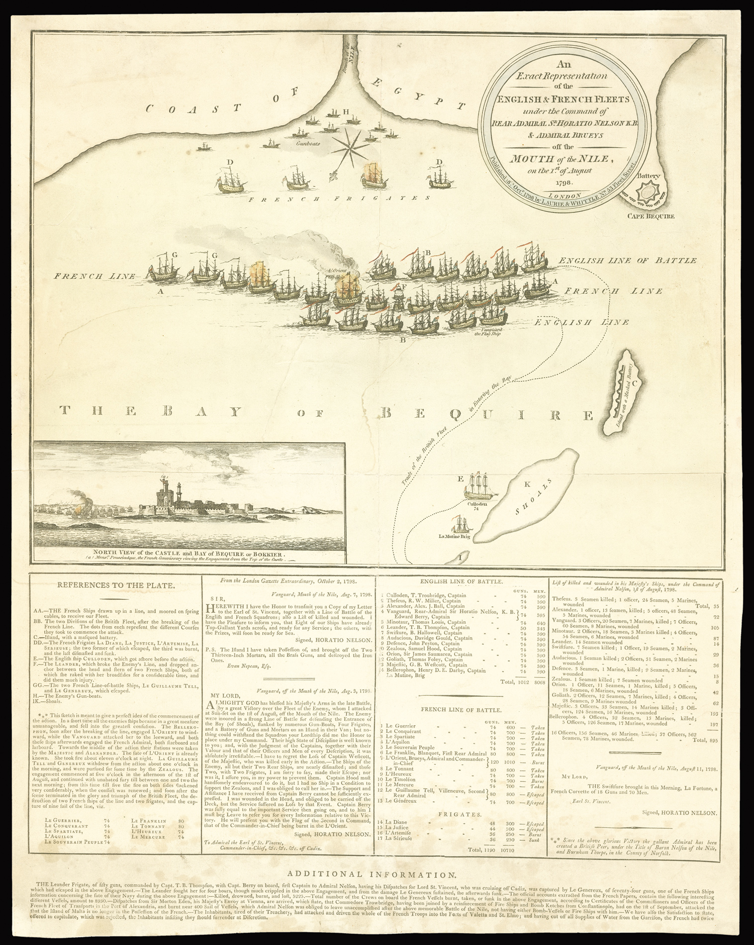
An Exact Representation of the English & French Fleets, under the Command of Rear Admiral S.r. Horatio Nelson K.B. & Admiral Brueys off the Mouth of the Nile on the 1.st of August 1798.
- Author: LAURIE & WHITTLE
- Publication place: London
- Publisher: Published by Laurie & Whittle, No. 53 Fleet Street
- Publication date: 18th Oct[obe]r, 1798.
- Physical description: Engraved broadsheet map, original hand-colour, with explanatory text below, a few old tears skilfully repaired, backed on japan paper.
- Dimensions: 560 by 450mm (22 by 17.75 inches).
- Inventory reference: 2134
Notes
Fine and rare plan of the Battle of the Nile.
The present plan was published a mere two and a half months after the battle – a very short time considering Nelson’s official dispatches were only printed in the “London Gazette” on the 2nd October. The plan shows the height of the battle, with the British ships attacking the French on the leeward and the windward sides. Three French vessels are shown ablaze, most notably their Flag Ship l’Orient. To the lower left is an inset view of the castle and bay of Bequire or Bokkier (Abu Qir), in which the French commissary Poussielgue is shown viewing the action from atop the castle’s keep. Below the plan are a key; extracts from the London Gazette; a list of the English and French lines of battle; and a list of the English killed and wounded. The text below this gives further information on the number of French casualties in the battle together with the news that the Maltese had begun a revolt against French rule.
Bibliography
- BL Cartographic Items Maps * 64465.(2.)
Related items


Sign up to hear about our latest acquisitions, exhibitions and events
Find Us
New York
PO Box 329, Larchmont, NY, USA
Opening hours, London Gallery
Monday to Friday: 10:00 – 18:00
Saturday: by appointment
Closed: all bank holidays and 1-31 August
Opening hours, New York
By appointment only