 Rare Maps
  Rare Atlases
  Rare Books
  Rare Prints
  Globes and Planetaria
 Sign up to hear about our latest acquisitions, exhibitions and events


Find Us
New York
PO Box 329, Larchmont, NY, USA
Opening hours, London Gallery
Monday to Friday: 10:00 – 18:00
Saturday: by appointment
Closed: all bank holidays and 1-31 August
Opening hours, New York
By appointment only
Opening hours

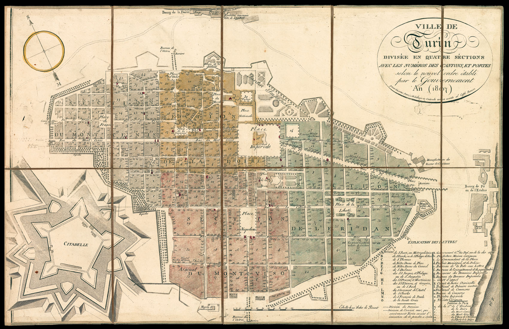
Ville de Turin Divisée en Quatre Séctions avec les Numéros des Cantons, et Portes selon le nouvel ordre établi par le Gouvernement.
- Author: Anonymous
- Publication place: Turin
- Publisher: Giacomo Pernigotti Librajo in Contrada nuova acanto al Caffe Paraca
- Publication date: 1807.
- Physical description: Engraved folding map, dissected and mounted on linen, contemporary hand colour.
- Dimensions: 420 by 642mm. (16.5 by 25.25 inches).
- Inventory reference: 10829
Notes
Turin was annexed to France by Napoleon Bonaparte in 1802, until his fall in 1814. The city became the capital of the Eridian department and the commercial link between Italy and France.
During this period, the shape of the city changed considerably. Most of the bastions were dismantled, except for the Citadel, the bastions of San Giovanni and Santa Adelaide, and the ones inside the Royal Gardens; the city walls were substituted by tree-lined promenades which linked the large squares along the perimeter of the city; a new bridge was built over the Po’ to replace the wooden one, using the materials from the dismantling of the bastions.
The city is divided into four sections: Séction du Mont Cenis, Séction de la Doire, Séction du Mont Viso, Séction de l’Eridian. These are further divided into numbered districts and within these, numbered houses. In 1808 Napoleon introduced the system that was first used in Paris of naming every street and giving a number to every house in order to identify the exact address of the inhabitants.
The key to the right lists the parishes and the notable buildings. The hatched line divides the parishes and the dotted line shows the old wall that encircled Turin prior the invention of the gunpowder.
Rare, we are unable to trace an institutional copy of the present map. The OCLC gives locations for 3 published by Honore Derossi in 1803 and 1808.
Related items


Sign up to hear about our latest acquisitions, exhibitions and events
Find Us
New York
PO Box 329, Larchmont, NY, USA
Opening hours, London Gallery
Monday to Friday: 10:00 – 18:00
Saturday: by appointment
Closed: all bank holidays and 1-31 August
Opening hours, New York
By appointment only