 Rare Maps
  Rare Atlases
  Rare Books
  Rare Prints
  Globes and Planetaria
 Sign up to hear about our latest acquisitions, exhibitions and events


Find Us
New York
PO Box 329, Larchmont, NY, USA
Opening hours, London Gallery
Monday to Friday: 10:00 – 18:00
Saturday: by appointment
Closed: all bank holidays and 1-31 August
Opening hours, New York
By appointment only
Opening hours

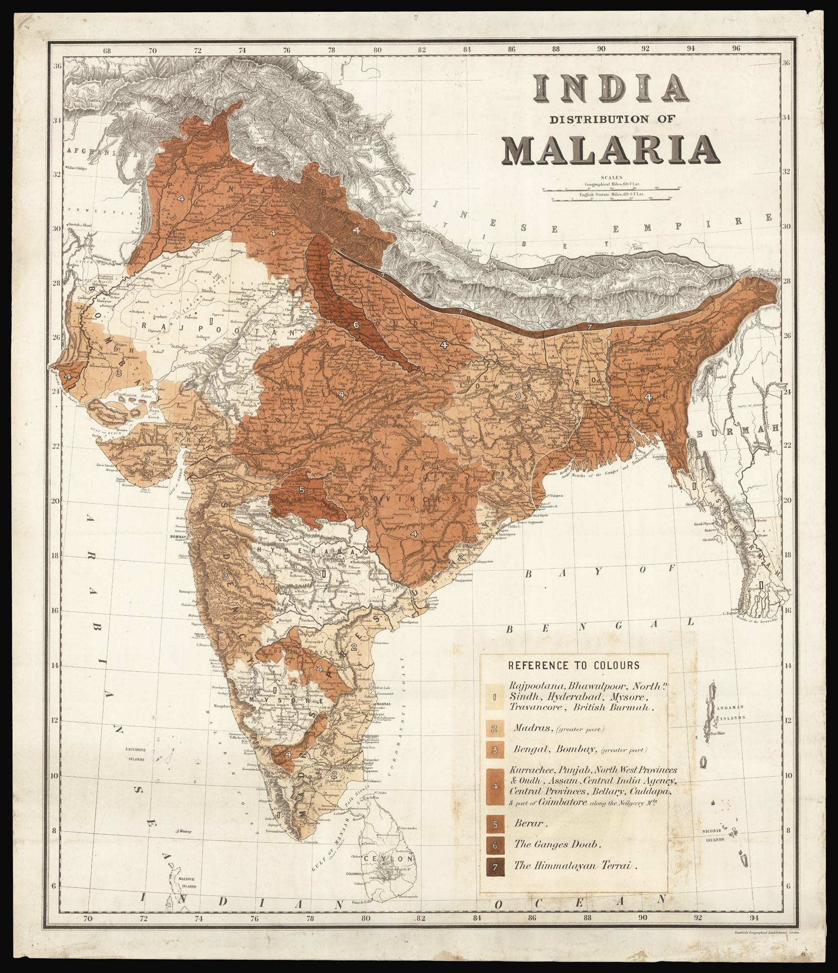

India Distribution of Malaria.
- Author: PUBLIC HEALTH COMMISSIONER OF INDIA
- Publication place: London
- Publisher: Stanford Geographical Establishment
- Publication date: c1880
- Physical description: Lithograph map, original hand colour, part of title in manuscript, key in manuscript and inserted to lower right.
- Dimensions: 790 by 680mm. (31 by 26.75 inches).
- Inventory reference: 14312
Notes
Unrecorded map of India showing the national distribution of malaria.
Malaria was the second biggest killer in colonial India after cholera; from 1800 to 1921, an estimated 20 million people died of the disease.
Although malaria was already endemic in India, the nineteenth century saw a dramatic spread of the disease. A key cause was the establishment by the British government of a railway system, and an irrigation and canal network, without providing adequate drainage systems to combat floods and excess rainfall. The lack of drainage created stagnant water in which mosquitoes could breed. The high death rate, the resulting economic effects and the risk to the lives of British officers serving in vulnerable areas like the Punjab, encouraged new research on malaria control. In the 1840s, attention was paid to proper drainage and chemoprophylaxis was started with quinine. The colonial government would get through some nine tons of the drug annually by the 1850s.
The present map was produced around 1880, most probably under the auspices of the Public Health Commissioner of India, which had been established in 1869. The map shows the distribution of malaria throughout India and British Burma, with seven degrees of severity: from (1), a pale wash showing a low concentration of the disease; to (7), a dark brown wash showing a high concentration of the disease. The key to the lower right lists the regions and their position on the malaria scale. These are:
1: Rajpootana, Bhawulpoor, Northern Sindh, Hyderbad, Mysore, Travancore, British Burmah.
2. Madras (greater part)
3. Bengal, Bombay (greater part)
4. Kurrachee, Punjab, North West Provinces & Oudh, Assam, Central India Agency, Central Provinces, Bellary, Cuddapa, & part of Coinbatore along the Neilgerry Mountains.
5. Berar
6. The Ganges Doab.
7. The Himmalayan Terrai.
The map shows that the states south of Hyderabad, apart from a few localised areas, were generally free of malaria. The disease is concentrated in the north, with ‘Rajpootan’ (Rajasthan) a notable exception. Particularly badly affected areas include Delhi, Lucknow, and a long strip along the feet of the Himalayas.
The map is part of the attempts of the British in India to gain a better understanding of the spread and cause of the disease towards the end of the nineteenth century. At about the time the map was produced, Surgeon Major Sir Ronald Ross joined the Indian Medical Service. In August 1897, he demonstrated the life cycle of the malarial parasite, and showed that anopheles mosquitoes carried the protozoan parasites called “plasmodia”. He was later knighted and given a Nobel Prize in Medicine in 1902. This discovery changed malaria research and focused malaria control programs on the eradication of mosquitoes.
We are unable to trace any institutional examples of malaria maps on of India, on such a large scale, published in the nineteenth century.
Scale: 69.1 statute miles to 1 degree of Latitude.
Image gallery
Related items


Sign up to hear about our latest acquisitions, exhibitions and events
Find Us
New York
PO Box 329, Larchmont, NY, USA
Opening hours, London Gallery
Monday to Friday: 10:00 – 18:00
Saturday: by appointment
Closed: all bank holidays and 1-31 August
Opening hours, New York
By appointment only