 Rare Maps
  Rare Atlases
  Rare Books
  Rare Prints
  Globes and Planetaria
 Sign up to hear about our latest acquisitions, exhibitions and events


Find Us
New York
PO Box 329, Larchmont, NY, USA
Opening hours, London Gallery
Monday to Friday: 10:00 – 18:00
Saturday: by appointment
Closed: all bank holidays and 1-31 August
Opening hours, New York
By appointment only
Opening hours

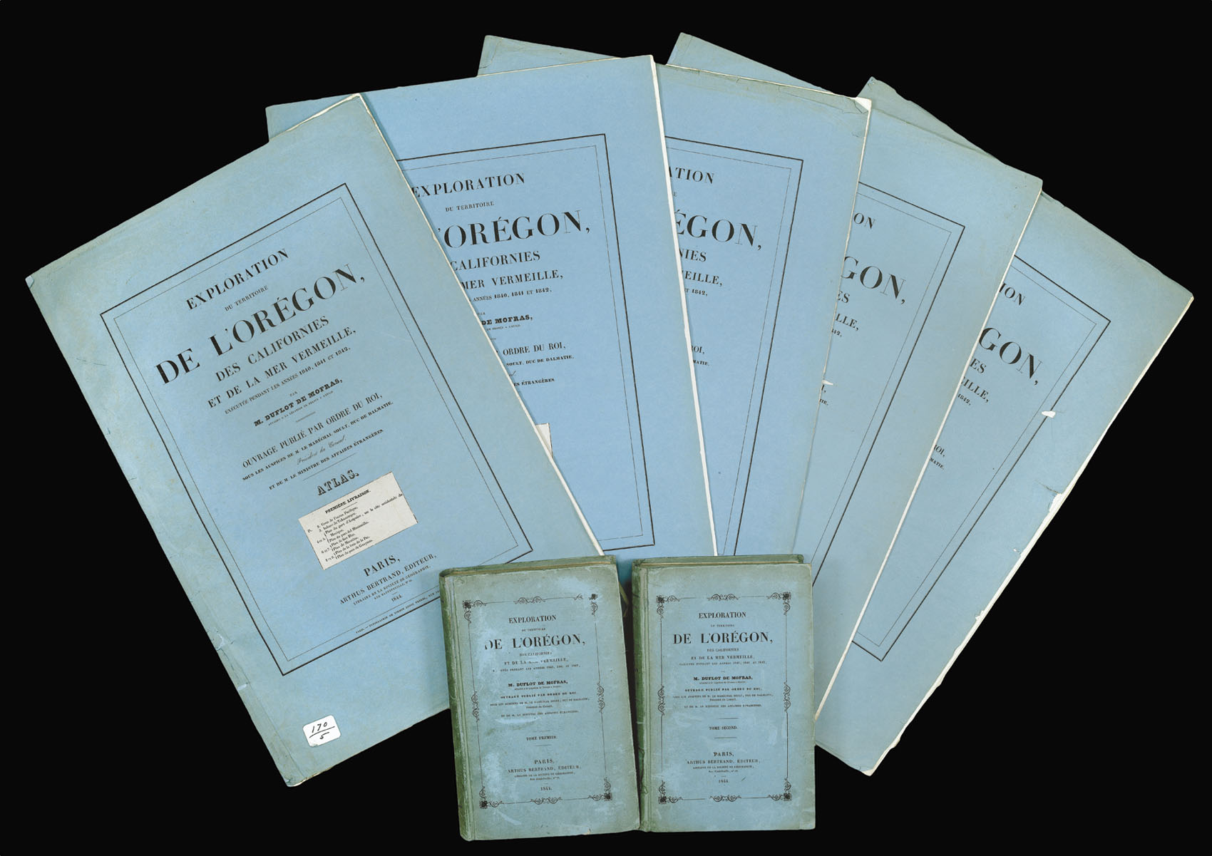

Exploration du Terretoire de l'Oregon des Californies et de la Mer Vermeille, exécutée pendant les années 1840, 1841, et 1842.
- Author: DUFLOT DE MOFRAS, Eugene
- Publication place: Paris
- Publisher: Arthus Bertrand
- Publication date: 1844.
- Physical description: 3 volumes: 2 text, and one atlas. Text: 8vo., (150 by 240mm) xii, [4], 524; [4], 514 pp., eight engraved plates, original blue paper over boards. Atlas: folio (555 by 375mm), in five fascicles, as issued, half-title, table of contents, and 26 engraved plates on 19 leaves, 23 of which are maps or plans, a large folding map hand-coloured in outline, each section, in original blue paper wrappers with publisher's printed paper label.
- Inventory reference: 12160
Notes
A rare work providing the earliest European perspective of Oregon and the west coast of America, and the most detailed book on California before American occupation. This example is inscribed on the front free endpaper of each text volume “a Son Excellence, Monsieur Le Comte Maurice de Dietrichstein, hommage respectueux del’auteur D. de Mofras”
Maurice Dietrichstein (1775-1864) was released from a French prison by Napoleon in 1800, and eventually became tutor to his son Napoleon II, 1815-1832, when the young man died. He was also musical director of the Imperial Court from 1819, and from 1821, director of court theatres. In 1826, he was appointed director of the Court Library, a post which he held until 1845, during which time he famously acquired the original score of Mozart’s ‘Requiem’. From 1833 – 1848, he was also director of the Imperial Cabinet of Medals and Antiquities.
Eugène Duflot de Mofras (1810-1884) a French diplomat, was appointed attaché to Mexico and sent to investigate Alta California and the Pacific coast from 1841-42. His special mission was to explore and evaluate the commercial possibilities of California and the Oregon Territory, which was the subject of dispute between the United States and Great Britain at the time. Duflot de Mofras did not endear himself to the Spanish community in America – he reputedly stole altar wine from the house of one family he stayed with and insulted the General meant to be helping him with his passport (Beebe and Senkewicz). This did not prevent him from creating an ambitious and comprehensive work, accompanied by these meticulously charted maps.
The first section contains a map of the Pacific Ocean with the area of America under dispute outlined in red, and plans of ports in Mexico. The second section contains plans of ports in California. The third section contains plans of ports in Alaska and Canada. The fourth section contains prints of Native American culture, including the mummified head of a three-year-old child, and goods including basketwork and weapons. It also has a plan and view of the St Luis Rey Mission, named after the French thirteenth century Saint-King Louis IX, founded by Franciscan monks and surviving to this day. The fifth part contains the standout piece of cartography: the large folding map of the west coast, which “made these western regions known in European official circles” (Wheat). It covers the area from Mount St Elias to Acapulco and reaches as far inland as Austin.
Provenance
1. Presentation inscription to Prince Moritz of Dietrichstein (1775 – 1864), an Austrian nobleman who held several high offices at the Imperial court; these included Director of the Imperial Court Theatre (Burgtheater) and Library (Kaiserlichen Bibliothek), and Keeper of the Privy Purse (Oberstkämmerer) 1845-1848.
2. The Society of California Pioneers, San Francisco
Bibliography
- Forbes 1461
- Phillips Atlases 1457
- Streeter sale 3323
- Rose Marie Beebe and Robert M. Senkewicz (trans. and ed.), Testimonios: Early California Through the Eyes of Women, 1815–1848 (University of Oklahoma Press, 2015), pp.64-67
- Cowan I, p 74. Cowan II, p 186
- Hill, p 87
- Holliday 319
- Howes D542
- Lada-Mocarski 120
- Van Nostrand & Coulter California Pictorial, pp 38-39
- Wheat Transmississippi West 474
- Maps of the California Gold Region 19
- Zamorano 80 30.
Image gallery
Related items


Sign up to hear about our latest acquisitions, exhibitions and events
Find Us
New York
PO Box 329, Larchmont, NY, USA
Opening hours, London Gallery
Monday to Friday: 10:00 – 18:00
Saturday: by appointment
Closed: all bank holidays and 1-31 August
Opening hours, New York
By appointment only